All Posts (11086)

Sort by

BeagleBone Black available - if you're quick.

Hi all, Beagle Bone Blacks are available at Adafruit this morning.

3689578832?profile=original

I wouldn't ordinarily put an Advertisement for a product as a Blog but as you may or may not know, Beagle Bone Blacks are seriously hard to come by.

Everybody is out of stock all the time, except a fewy unscrupulous dealers who jack up the price - a lot.

Adafruit has a notify service and today they got both Beagle Bone Blacks and the BBB Starter kit (which is a really super deal).

I already had a BBB from them but also wanted a starter kit so signed up for notify again.

http://www.adafruit.com/products/1278

http://www.adafruit.com/products/703

My Starter kit is now on order (didn't think I'd tell you about it till I ensured mine did you?)

In any case if you want a BBB, now's the time - if you are really quick.

Best Regards,

Gary

Read more…

Pixhawk installed in Vulture 2 spaceplane

Hot off the press, a quick exclusive snap of the complete Pixhawk rig installed in our Vulture 2 aircraft, and ready to roll.

3689578697?profile=original

Details of the installation to follow, but suffice it to say, it's a tight fit. The Pixhawk buzzer isn't indicated, but sits under the autopilot.

We haven't yet hooked up the Raspberry Pi to the Pixhawk, fearful of a Skynet-style self-awareness incident. That connection will enable us to programme the autopilot via the Pi.

The Pi is lacking its breakout board, which will have a GPS, and Radiometrix transmitter to beam live images from the nose-mounted Picam, as well as acting as a primary tracker. It'll also have a multi-axis accelerometer to record just how horribly everything went wrong just what a triumph the mission was.

The PAVA tracker is a miniature back-up radio transmitter with GPS. There's more on the LOHAN mission here.

Read more…
100KM

Camera bay doors coming soon for techpod.

Hello everyone,

wpid-20140304_104427.jpg?width=300


I just wanted to show off what I've been working on lately for the techpod. Is a mechanism to at automatic doors to the camera bay of the techpod. This will allow people to mount a camera in the belly of the techpod and gather unobstructed vertical photos and still keep the camera protected during landings etc.

wpid-20140304_104439.jpg?width=300wpid-20140304_104446.jpg?width=300

Read more…

In a previous post on diydrones I showed how to make a mesh model for visualization or games from a landscape surveyed by a drone. That workflow started off with the set of bare 2D images and used VisualSfM and CMPMVS to generate the point cloud and camera parameters.

VisualSfM and CMPMVS take a long time to run though and do not always produce the best end results. The commercial alternatives, like pix4d/agisoft/menci/etc. also generate parameter files that contain the camera positions and, with a bit of processing, may produce better point clouds. I wanted to find out if I could script those results and get similar outputs, so I wouldn't have to depend on my own runs to start working in 3D. At least it would take less time to process.

I added some excitement by rendering a 3D SBS video of the end results. Stuff used: pix4d output files and parameters, a custom script to generate bundler.out and list.txt files, meshlab, cloudcompare and blender.

Meshlab expects the camera parameters as a rotation matrix with a translation applied afterwards, not the actual camera position. The geocal file from pix4d contains the position however. A bit of math though shows that T=[-RC] (translation=[-rotation*position], so this is easily derived. The rotation matrix R is calculated from the euler angles, as the matrix in the metriccal file uses a different convention for the axises.

The texturing of the mesh was done as in the other example, but this time I used the point cloud from pix4d only, slightly tweaked by cloudcompare. The pix4d point clouds are in UTM projection, so I had to apply a global shift and then remove that shift manually, bringing the point cloud to some local coordinate system for easier processing. If not, the numbers are too big for visualization. The same global shift was later applied to the camera positions in the custom processing script.

In the end I only had to import the OBJ into blender, set up a stereo vision camera rig, define a path for the camera to follow, join the stereo rendered images together in 3D Side-By-Side fashion and render an animation from the image strip.

It's clear that the level of detail is really low, both in texture and geometry, but that's because the point cloud was downsampled a bit too far and the poisson surfacing was not very aggressive in maintaining angles. It's possible to get better results by maintaining high point density, apply the poisson a bit more aggressively and subdivide the mesh. The most important issue here though was that the overlap was very low. The source material must be of high quality to begin with. Trees and such are flat and projected on the ground because there was far too little information to reconstruct them. Trees with leaves become hunks of goo due to the poisson surfacing. Those are issues that need to be tweaked by hand.

From here, the sky is the limit: import the APM log and refly the mission on this virtual terrain, add some trees, remodel the mesh with primitives to get better looking results, add sky boxes, animate stuff, script this with the blender game engine and make it navigable using the Oculus Rift, use any other game engine to import the landscape and create interface apps that "do" stuff in the real world. For example: plan your mission virtually by flying through it in 3D, then collect the curve and build a list of waypoints.

This experiment shows that it's possible to get miles ahead in a 3D visualization project when you've surveyed the area by a drone first. It takes 4 hours to collect the data, a day to process them 'in the cloud' and only half an hour to get your OBJ from the end results. That means you can have a 3D model of the area ready for remodeling and editing in 2 days.

Read more…
3D Robotics

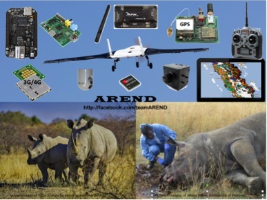
From Kickstarter, an APM-powered fixed wing drone project: I've backed it!

An international student team (Team AREND) is collaborating to compete in the Wildlife Conservation UAV Challenge to design, build & fly an unmanned aerial vehicle (UAV) in support of anti-poaching operations in South Africa.  This student team is led by Dr. Jean Koster at the University of Colorado at Boulder, and includes teams from Helsinki Metropolia University of Applied Sciences, Finland, the University of Pretoria, South Africa, and the University of Stuttgart, Germany.

We are especially pleased to collaborate with the University of Pretoria in South Africa, specifically their CSIR Aeronautical Group and the Centre for Wildlife Management.

Team AREND OrganizationTeam AREND Organization

Also collaborating with and supporting / sponsoring this student team is Helios Torque Fusion, Inc., NIST - the National Institute for Standards and Technology, First RF Corp. of Boulder, Colorado, Blue Atmos, LLC of Denver, Colorado, Four Winds Interactive Inc. of Denver, Colorado, the Arvada Modelers club and many technology experts from the region.  Helios Torque Fusion, Inc. is a Colorado-based business working to commercialize hybrid-electric propulsion systems for UAVs, making the aircraft more fuel-efficient and quiet - both important for wildlife monitoring & protection.The African Conservation Foundation supplies us with poaching information material so we can create a better solution to the unique challenges presented.

Read more…

3689578554?profile=original

Thousands of designs, stored all over the world, a few scattered here and there on Diydrones and other fileshare sites.

http://caddrones.com/blogs is a great place to share your designs.

It is very similar to DIY drones in layout, function and community, it uses the same logon services and is just as useful.

IF you do anything after reading this, let it be to check out CAD drones, and go wild, Say Hi!

Post a few pictures of your RC device , some files of your designs, it only takes a few minutes.

I have already copied my entire design library over 30 designs!

and there are lots of interesting designs from me and others.

You may even find a design you like, maybe its your next project!

Go have a look!

Read more…
3D Robotics

3689578385?profile=original

From TechCrunch:

Facebook, one of the primary backers of the Internet.org initiative, which aims to bring affordable Internet access to the 5 billion people in the world who still lack connectivity, is in talks with a company that could help further that agenda. TechCrunch is hearing that Facebook is buying Titan Aerospace, makers of near-orbital, solar-powered drones which can fly for five years without needing to land. According to a source with access to information about the deal, the price for this acquisition is $60 million*.

From our understanding, Facebook is interested in using these high-flying drones to blanket parts of the world without Internet access, beginning with Africa. The company would start by building 11,000 of these unmanned aerial vehicles (UAVs), specifically the “Solara 60″ model.

You can see an example of these UAVs, first introduced last year, here on YouTube. As the video explains, these drones are “atmospheric satellites” that can conduct most of the operations of an orbital satellite, but are cheaper and more versatile. The drones could potentially have many uses, including weather monitoring, disaster recovery, Earth imaging, or communications, the company has said, but clearly Facebook would be interested in that latter part.

The Solara 50 and 60 models can be launched at night using power from internal battery packs, then when the sun rises, they can store enough energy to ascend to 20KM above sea level where they can remain for five years without needing to land or refuel. Such capabilities make them ideal for regional Internet systems, like those that Internet.org would be focused on. (For those interested, Ars Technica took a more in-depth look at the technology and history behind Titan’s aircraft last August).

Titan Aerospace is a privately held venture with R&D facilities in New Mexico. The company has raised an undisclosed amount of funding through seed and Series A and A-1 rounds, and had announced in October 2013 it would open a B round soon.

Titan is currently led by CEO Vern Raburn, previously founder and CEO of Eclipse Aviation. The company was founded in 2012 by Max Yaney (CTO), in order to produce what it refers to as “atmosats,” new types of UAVs that do the work of near-Earth satellites at a fraction of the cost.

The designation of “satellites” is important here, as the idea has been to position these aircraft above the airspace that the FAA regulates in the U.S. Class A airspace ends at 60,000 feet stateside, and above that the U.S. doesn’t regulate, Fortune had pointed out last summer. That means the only issue in launching these in the U.S. would be the initial climb. In other parts of the world, the laws will, of course, vary. But in the developing markets Internet.org is focused on, it’s likely they’re not as far along in regulating such new technology.

Following the acquisition, all of Titan Aerospace’s production would be for the Internet.org project only, according to a source familiar with the matter.

Facebook’s Own “Project Loon,” Worth Less Than WhatsApp?

The Internet.org project competes with Google’s own R&D effort called “Project Loon,” which would involve balloons, not aircraft. TechCrunch had previously heard that Facebook has its own counterpart to “Project Loon” in the works, and this could be a part of that agenda.

In any event, if you’re keeping score at home, that’s $60 million to bring Internet to the world, and $19 billion for WhatsApp. That may seem odd, but this acquisition and WhatsApp would share the same broader goal of making the Internet more accessible, from Facebook’s point of view.

If Facebook could project weak but free Internet to developing nations via Titan Aerospace drones, it could then make a basic version of WhatsApp available to those users. They may not be able to send or view photos, but they likely could send messages and view status updates, even if they only had a weak, slow connection.

Facebook’s acquisition of Onavo could lend a hand, too. We hear the team is hard at work on data compression technologies that would allow the same functions to require less transmitted data to complete. Onavo-optimized WhatsApp or Facebook apps could run on a weaker Internet signal, such as from drones, because they don’t need to send or receive as much data.

Many ask why Facebook would even care about getting these parts of the world on the Internet if they currently have such little buying power that it’s hard to make money off of ads shown to them. There’s the altruistic side of Internet.org, but when it comes to business, Facebook is playing the long game. It hopes that with time, everyone in the world will gain affordable access to the Internet and smartphones, which could help them join the knowledge economy and gain more buying power.

If Facebook can use Titan’s drones to be someone’s first experience on the Internet, they’re likely to get deeply hooked into the social network’s service and eventually become a lucrative lifetime user.

Read more…

This video presents the latest iteration of  IDSC's Flying Machine Arena failsafe algorithm (previous post here). In this video there's a pilot flying the quadrocopter while the algorithm is executed on the quadrocopter's onboard micro-controller. The only sensors required are the quadrocopter's angular rate gyroscopes.

You can read more on the description of the video ( https://www.youtube.com/watch?v=ek0FrCaogcs ) 

You can read an older article about the failsafe algorithm mentioned above with more details and photos here:

Quadrocopter failsafe algorithm: Recovery after propeller loss

(take a look at the comments below!) 

You can also read Robohub's coverage on Amazon's Prime Air and other Quadcopter related articles.

(video link via M.Waibel)

Read more…

This worries me because I currently living in France and am nearing the completion of my first quadcopter. French laws are known to be difficult to navigate at best!

It raises an important question: What does the future hold for small UAV technology in Europe?

From the article here: http://www.thelocal.fr/20140214/french-drone-flyer-faces-public-endangerment-charges

Nancy seen from the air” (Nancy vu du ciel) a stunning short film put together by 18-year-old Nans Thomas quickly racked up some 400,000 views in a matter of days after it was posted on the online video sharing site Vimeo.

The beautiful images of spires, churches and plazas of the historic north-eastern French town were captured in a unique way by attaching a go-pro camera to a drone.

At one point the video was reportedly even hosted on the social interactive site of the regional council of Lorraine. 

But unfortunately for the teenager the success also caught the eye of French civil aviation authorities, who ordered an investigation, TF1 TV reported. It turns out the teenager violated two key provisions of the law according to Nancy’s top prosecutor Thomas Pison.

First, drone operators in a France have to complete a training course similar to the ones pilots must take. Then, a drone flight over an urban area requires specific written approval. Unfortunately for Thomas, he had neither.

“I had no idea you needed permission (to fly it),” Thomas told French paper Est Republican. “Nobody gave me any indication that I needed any special permission when I bought it on the internet.”  

The first bad sign came when he got a letter from aviation authorities (Direction Regionale de l’Aviation Civile) which reminded him of the rules. 

On Monday things got worse. Thomas got a call from the police who wanted to talk to him as soon as possible about the drone flight and the resulting film. He went to police and left with a court summons on charges of “endangering the lives of others.”

Prosecutors didn’t think Thomas’s little stunt was too funny.

“If the aircraft crashed in a densely populated area, the consequences can be tragic,” prosecutors told Est Republican. “The use of drones also raises the question of respect of people’s privacy.”

Here is the video. It's too bad it was filmed illegally, because its pretty spectacular.

Read more…
100KM

3DR Iris...Simply amazing

3689578346?profile=original

Talking about stability, how about this?

https://www.youtube.com/watch?v=nqjImLGDYrM

First and foremost, I have nothing to do with 3DR but is regular customer.

I order the Iris on Nov 2013 and just received it last week. After a few flights with it, I think the waiting time is well worth of it and we have a winner here. 

The Iris simply lift off and settle in a VERY stable hover on my first flight in Alt hold mode. after flying for a few minutes I switch to loiter mode and it hold position and altitude well. left and right pirouette are also very good. Unlike DJI Phantom, it simply spin on the spot while the DJI will wonder in a radius about 2 meter when perform the same maneuvers. 

I also try a few auto mission and the default setting is just fine. Navigation is good which track the grid line very well. Until now, I have not touch a single thing in the parameter list. I am really appreciate all the hard work done by the developers and the beta testers. Now we just enjoy flying it without any hassle.

The Iris package is also truly ready to fly. If you have a/c power source at your flying field, you simply install the propeller, install transmitter battery and charge the included 3S Lipo battery with the included charger, an hour or so you can have your maiden flight with it.

So far my Iris will fly about 13 minutes before the LED light flashing. Flying distance is about 3 KM without load. With a Gopro Hero 3 in front, I have flown 1.7 KM with plenty of reserve. I think 2 KM is well within it's range.  

I will bring the Iris as my back up unit to Medan, Indonesia tomorrow for a Al Jazeera documentary video shooting by Banyak films, UK. If the Iris appear on TV, I may contact Chris for some advertisement appearance fees.........well, just kidding. 

Anyway, I'll highly recommend anyone who want to try multi rotor with mission planing capability, you will not disappoint with the new Iris.

3689578367?profile=original

Read more…

APM stabilised spotlight (SAR application)

My second flight with the hex, after a maiden inc autotune*. It's my workhorse, and it's back to work! No real issues, apparent from a faulty AR8000 rx which seems to generating some CH3 "blips" if CH8 is connected. Weird...


This is a very dark night (no moon, full cloud coverage), so I figured a perfect time to see how my stabilised spotlight performs. And it performs....ok. Ish. Unfortunately, it's really *really* difficult to film this, as you'll see. The nex5 struggles to pick up all the light - you can see me supposedly walking right out of the beam at one point on the film, but actually, I I was still generating a shadow!


1. Yes, it's stabilising, but the response on the roll axis is far too weak, both on latency and response. I might need to search more leverage vs bigger servo. What can I do with the APM, to increase "P" on the roll axis?


2. Both axis lack the response time and accuracy of brushless but frankly, for a spotlight, that's not too much of an issue. Just fixing my PID's will help a lot. Since it will be used to support ground searches, it merely has to track at slow speeds, and in a consistent manner.


3. The light itself is rated at 9,800 lumen. Chinese Lumen...But I could still do with more power. Also, a more even and round beam would be nice - it's strangely square with too much of the beam focused in a narrow beam in the centre. But it was cheap! For a much more even spread, I'm going to have to try and find a better unit. Hmmm.


4. The test was just stabilisation. I forgot to demonstrate the forward-looking beam (ie points forward at 45')...it's surprisingly effective.


5. This gimbal only has about 80' of rotation on both axis; this makes point 4 difficult to perform while moving. You won't be chasing speedboats with cocaine or joyriders with this just yet...


3689578326?profile=original


* Autotune missed again with this one...my last two were too soft, this one is too hard! P of 0.17  and D of 0.15 for a 6S hex is too much. I've tuned it back to P0.1, but it's still too much. P of 0.09 and D of 0.010 is probably the sweet spot.

Read more…

Finally I have a good UAV ground station.

Having completed many UAV filming jobs from locations without vehicle access I was looking to improve the logistics of getting the equipment on site. I have occasionally left some vital components in the car 2km away I wanted to have everything (except the copter) in one box.

An old golf caddy was shortened to allow it to stand more upright and modified to allow the toolbox to clip on. The tray clips onto the handle with 28mm pipe clips.

I am using a 12v 7Ah PB to power a TFT screen, Nexus7 tablet and VRX. The weight of this battery makes the base very stable. The video feed is repeated in the fatshark goggles.

The octa arms fold and it can be carried on top of the box, leaving one hand free.

Read more…

  About a year ago I first saw Ken McGary of Nerds for Nature present on the potential use cases for sUAV and ecological sensor data collection.

3689577990?profile=original

.Last weekend we ran the first in a series of tests to explore the feasibility of using UAV to test water quality. Over the past month or so this has gone from some drawings on a napkin to a proof of concept that performed near perfectly last weekend at a bioblitz at lake Merritt in Oakland CA. A better story of all that went on was in Scientific American.  

  We built a sensor array that had a thermal probe and pH sensor for our first trial.subsequent tests will incorporate salinity and dissolved oxygen sensors.

 One of the first challenges was to get the copter to land and remain stationary for 30-45 seconds while the sensors obtained their readings. "Condition_delay" is still in development but through some experimentation we found "loiter_time" with no GPS or Altitude info to do the trick. 


3689578054?profile=originalOur AeroTestra,specially outfitted amphibious multi rotor, autonomously took off, navigated to four separate way points collecting temperatures and pH levels at each, then returned to the home position to finish the routine. This initial test was all done a few meters off the surface of the lake and only 20-30 meters from the dock with me ready to assume manual control if things went south. 

 While crop inspection and 3D mapping and survey will prove to be the major use cases for this technology in the next few years, I feel like the wide open frontier of this type of research and sensor integration will open worlds of possibilities and feel very excited to be a part of it.

3689577823?profile=original


My sincere thanks to everyone involved including the ArduCopter developers, 3D Robotics, and Nerds 4 Nature.

 We will update with progress as it develops. Perhaps,come June, we will test the water in the Boulder Reservoir.:)

.
 

Read more…
3D Robotics

3689577945?profile=original

From Make:

MAKE is excited to head to Texas next week for one of the best events of the year, and we’re hoping to get more of the homegrown drone community involved.

We’ll be set up at SXSW Create from Friday to Sunday (3/7 – 3/9), and are bringing drone professionals and enthusiasts from 3D Robotics to Rice University to display and demonstrate their latest flying machines. We’ll be handing out copies of our new “Homegrown Drones” issue, talking with thousands of visitors, and generally just having a blast.

We’ve saved table space for a couple additional enthusiasts to take part with us at what promises to be a very fun weekend, and would love to chat with local drone-flying groups that would like to help us take over the sky in front of the Long Center. If your team is around and want to get involved, email us: msenese@makermedia.com

And for those who may not be able to participate for the full three days, we’re doing an open-fly session every afternoon from 4pm to 6pm. The SXSW Create event is free, so if you’re interested, email or just come by. It’s going to be amazing.

When: 3/7 – 3/9

Time: 11am–6pm; open fly from 4pm-6pm

Where: Long Center, Austin

Contact: msenese@makermedia.com


Read more…

Accident opens eyes to future

3689577899?profile=originalhttp://www.odt.co.nz/news/farming/293307/accident-opens-eyes-future

While riding a bike about 15 months ago, spatial analyst Neill Glover was hit by a car and seriously injured. While recovering, he had plenty of time to think about work. That is where his drone came in.
He bought a SkyJib-X4 unmanned aerial vehicle (UAV), from Aeronavics, of Raglan, and started Geo and Spatial Information Systems Ltd about three weeks ago.

''I prefer to call them UAVs or rotary robotics because the word `drone' had spying and military connotations,'' Mr Glover said.

He learned how to use the drone, added some features, and now offers a farm mapping, photogrammetry (the science of taking measurements from photographs) service and egg and bird-nest counting.

He said the UAV took images in much finer detail than planes or satellites. While he keeps the UAV to a maximum height of about 400ft (low-flying aircraft are not allowed to go below 500ft), it can detect a piece of wire on the grass.

As the UAV has a gimbal, it stays upright in reasonably windy conditions. It can travel up to about 45kmh and can fly 3km to 4km away, although he prefers to operate it within sight.

The UAV has an infra-red camera and may be used to find faults on pylons or wind turbines. The infra-red system could be used for search and rescue, to pick up a missing or injured person's body heat.

''There are huge area of untapped potential,'' he said.

- by Yvonne O'Hara

Read more…

Announcing MAVBoard Indiegogo Campaign

3689577854?profile=original

I have finally got the MAVBoard to a state where I am ready to take pre orders via Indiegogo! After several revisions of the boards, I am quite happy with them and would like to take pre orders so I can get a large batch of them made.

Here is the description of the MAVBoard from the campaign:

The MAVBoard is a way to share a single MAVLink telemetry connection (the telemetry port on a 3D Robotics APM 2.X, for example) among multiple devices, such as OSDs, telemetry radios, telemetry converters or other add-on boards. Until now, the solution is to create a custom soldered cable harnesses which are difficult to make and not as flexible, since only one device can be connected to the "Tx" pin of the MAVLink connection.


I ended up splitting the design into two models: MAVBoard Lite and MAVBoard Pro. The Lite board has no AVR chip, and is simply a bus for MAVLink connections, with a jumper to select the Tx device. The Pro board contains the AVR to do telemetry conversion, as well as has several digital and analog pins (including the ones for I2C) available at the edge of the board. The board is all SMD-component based now, and the size has shrunk quite a bit from the first prototype I announced last year.

I am hoping to get at least 100 in the pre-order, but I plan to make more than that. If you sell drone/multi-rotor parts online and would be interested in stocking the MAVboards, let me know.

So, with that, please checkout the campaign and support it if this project would be useful to you!

All feedback is welcome!

Read more…