All Posts (11086)

Sort by
3D Robotics

From NPR:

Can drones, the small unmanned aircraft that are at the forefront of fields from warfare to commercial delivery systems, fly without human intervention? A team of Hungarian researchers answers yes, having created 10 drones that self-organize as they move through the air.

The team based its creation on birds such as pigeons, which fly in tight bunches while making adjustments and decisions. They fitted quadcopters — drones with four rotors — with GPS, processors and radios that allow them to navigate in formation or while following a leader.

Like "gregarious animals" such as birds and fish, the flock of drones follows rules of collective motion, says Tamas Vicsek, a physicist who teaches at Budapest's Eötvös Loránd University. "We came to the conclusion that one of the best ways to understand how animals move together is to build robots — flying robots."

And like those animals, the drone flock was tested as it flew around in open fields, not in a controlled indoor test environment, as Nature's Ed Yong reports.

The drones can negotiate tricky paths, such as when their route becomes tightly confined. When that happens, some of them hover in place to wait their turn. And it's all done without a central computer or controlling device, the researchers say. Instead, they use "flocking algorithms," says Gabor Vasarhelyi, who led the robotics phase of the project.

The Hungarian team plans to demonstrate its drone-swarm research later this year in Chicago, at the International Conference on Intelligent Robots and Systems. Until then, you can read its latest paper, titled "Outdoor flocking and formation flight with autonomous aerial robots." (You can see a video explaining the team's work at the bottom of this page; we had to put it there due to its persnickety display.)

"Drones are most commonly associated with war, terrorism, and cyberattacks, but drones can be used in more peaceful civil applications as well," Vasarhelyi says. "With a flock of drones, you can create a self-organized monitoring system from the air, or you can even deliver food or mail."

Here in the U.S., drones are expected to someday buzz around carrying out commercial tasks — but not before the Federal Aviation Administration issues new regulations governing such activity. As we've reported before, Amazon is developing a drone delivery system.

And last month, a Minnesota brewery was told to stop its tests that used drones to fly cartons of beer out to fishermen.

The flock of drones also reminded us of an amazing set of videos that were highlighted on PetaPixel last month, in which Rhode Island School of Design artist Dennis Hlynsky illustrated the flight paths of dozens of birds in urban settings.

Hlynsky used a video-editing technique that's similar to one increasingly used in sports TV to make the flying birds' images linger and create streaming patterns.

Read more…
Moderator

FAA.jpg

Interesting press release from the FAA

Quoting from http://www.faa.gov/news/updates/?newsId=76240 :

February 26–There are a lot of misconceptions and misinformation about unmanned aircraft system (UAS) regulations. Here are some common myths and the corresponding facts.

Myth #1: The FAA doesn't control airspace below 400 feet

Fact—The FAA is responsible for the safety of U.S. airspace from the ground up. This misperception may originate with the idea that manned aircraft generally must stay at least 500 feet above the ground

Myth #2: Commercial UAS flights are OK if I'm over private property and stay below 400 feet.

Fact—The FAA published a Federal Register notice in 2007 that clarified the agency’s policy: You may not fly a UAS for commercial purposes by claiming that you’re operating according to the Model Aircraft guidelines (below 400 feet, 3 miles from an airport, away from populated areas.) Commercial operations are only authorized on a case-by-case basis. A commercial flight requires a certified aircraft, a licensed pilot and operating approval. To date, only one operation has met these criteria, using Insitu's ScanEagle, and authorization was limited to the Arctic.( http://www.faa.gov/news/updates/?newsId=73981)

Myth #3: Commercial UAS operations are a “gray area” in FAA regulations.

Fact—There are no shades of gray in FAA regulations. Anyone who wants to fly an aircraft—manned or unmanned—in U.S. airspace needs some level of FAA approval. Private sector (civil) users can obtain an experimental airworthiness certificate to conduct research and development, training and flight demonstrations. Commercial UAS operations are limited and require the operator to have certified aircraft and pilots, as well as operating approval. To date, only two UAS models (the Scan Eagle and Aerovironment’s Puma) have been certified, and they can only fly in the Arctic. Public entities (federal, state and local governments, and public universities) may apply for a Certificate of Waiver or Authorization (COA). The FAA reviews and approves UAS operations over densely-populated areas on a case-by-case basis.

Flying model aircraft solely for hobby or recreational reasons doesn’t require FAA approval, but hobbyists must operate according to the agency's model aircraft guidance, which prohibits operations in populated areas.

Myth #4: There are too many commercial UAS operations for the FAA to stop.

Fact—The FAA has to prioritize its safety responsibilities, but the agency is monitoring UAS operations closely. Many times, the FAA learns about suspected commercial UAS operations via a complaint from the public or other businesses. The agency occasionally discovers such operations through the news media or postings on internet sites. When the FAA discovers apparent unauthorized UAS operations, the agency has a number of enforcement tools available to address these operations, including a verbal warning, a warning letter, and an order to stop the operation.

Myth #5: Commercial UAS operations will be OK after September 30, 2015.

Fact—In the 2012 FAA reauthorization legislation, Congress told the FAA to come up with a plan for “safe integration” of UAS by September 30, 2015. Safe integration will be incremental. The agency is still developing regulations, policies and standards that will cover a wide variety of UAS users, and expects to publish a proposed rule for small UAS – under about 55 pounds – later this year. That proposed rule will likely include provisions for commercial operations.

Myth #6: The FAA is lagging behind other countries in approving commercial drones.
Fact – This comparison is flawed. The United States has the busiest, most complex airspace in the world, including many general aviation aircraft that we must consider when planning UAS integration, because those same airplanes and small UAS may occupy the same airspace.
Developing all the rules and standards we need is a very complex task, and we want to make sure we get it right the first time. We want to strike the right balance of requirements for UAS to help foster growth in an emerging industry with a wide range of potential uses, but also keep all airspace users and people on the ground safe.

Myth #7: The FAA predicts as many as 30,000 drones by 2030.

Fact—That figure is outdated. It was an estimate in the FAA’s 2011 Aerospace Forecast. Since then, the agency has refined its prediction to focus on the area of greatest expected growth. The FAA currently estimates as many as 7,500 small commercial UAS may be in use by 2018, assuming the necessary regulations are in place. The number may be updated when the agency publishes the proposed rule on small UAS later this year.

---

You can catch up with exactly what's happening with airspace integration at our show in May. Jim Williams will be speaking http://susbexpo.com/speakers-2014/ Jim Williams is the Manager of the FAA’s Unmanned Aircraft Systems (UAS) Integration Office. This office functions as the single agency focal point for all UAS-related activities and is uniquely positioned to develop and coordinate solutions to UAS challenges across the FAA and with external organizations.

Chris A will also be there.

Read more…
Moderator

Part 2 of the EastBay RC Guide to PID Controllers.

Building on the intuitive model presented in part 1, we take a look at the mathematical model and write a PID control loop based on that model. Hang in there if you're unfamiliar with the math... it turns out to be pretty straight-forward code in the end!

Like part 1, this is a first take. Your comments are welcome!

The printed formula is from wikipedia. I tried doing this Khan Academy style with a tablet... wow that's hard to write with, so I did it on paper instead.

Read more…
Moderator

Eye eye whats this then

HRChrisMueller166-620px-1392914004873.jpg

Interesting article at IEEE all about 3DR but it was the flying wing that caught my eye, along with a very relaxed image of Jordi. Is that just an RV Jet from a funny angle or is there something different about it? That's a good chuck to get it that high before the folding prop starts. 

The poster child for that elite is Jordi Muñoz. He broke off his studies in electrical engineering in Mexico to spend two years on drone technology, cranking out C++ code for a UAV autopilot based on the Arduino microcontroller. Anderson heard of the autopilot, ordered a test version, and began an online dialogue that ended with the two men’s founding of 3D Robotics. (The name refers to the one dimension where robots had not previously gone: up.)

HRChrisMueller3147-1392827544703.jpg

http://spectrum.ieee.org/aerospace/aviation/chris-andersons-expanding-drone-empire?utm_source=feedburner-robotics&utm_medium=feed&utm_campaign=Feed:+IeeeSpectrumRobotics+%28IEEE+Spectrum:+Robotics%29

Read more…

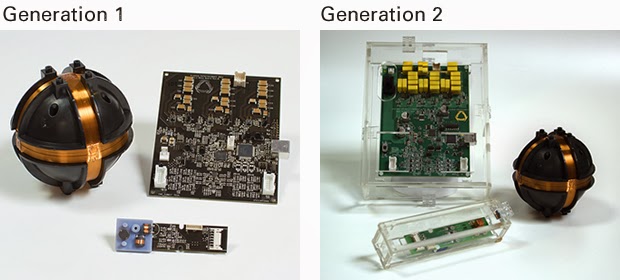
Electromagnetic position sensing

e7b53029be1d40fe4a97ef08d97538c7_large.jpg

https://www.kickstarter.com/projects/89577853/stem-system-the-best-way-to-interact-with-virtual

sixense.com

This was an interesting concept for indoor navigation.  It's 1 of those ideas you're always aware of but dismiss because the electromagnets would be too weak.  Someone actually tried it.
 
Magnetometers have gotten sensitive enough for it to work.  Barely visible in the photo are 3 large inductors used by the roaming unit to sense very faint electromagnetic oscillation from the base station.  The base has lots of capacitors for pulsing the coils with a very high current.

The roamer measures direction & intensity, but probably not time of flight.  The intensity measurement is probably very bad.  The 1mm precision they claim would be in tangential movement.  2 base stations could give it much better accuracy, but require alignment. 

Increasing the range could be a matter of bigger inductors or a bigger base station.  There are no teardowns or benchmarks. The consumers are all salesmen or reporters with no interest in how it works.  There's no data on its precision at its maximum range of 8ft. 

The advantages would be no calibration or alignment of cameras & no interference from ambient light.  You could throw the base station down anywhere.  In an explosion of lots of micro startups with lame ideas & no funding, this idea seems to have potential. 

They remind me of Invensense, initially targeting the news maker of the time: 3D printing, & conspicuously avoiding any mention of the giant elephant in the room: drones.  Invensense still targets phone cameras, making no mention of the millions of flying toys on their page.


Read more…
3D Robotics

Glider pilot surprised by drone in thermal

3689577497?profile=originalA disquieting report from our friends in the manned soaring world. Yet another reminder to STAY BELOW 400 FEET!


From Soaring Cafe:

One of the pilots in our local soaring club was surprised to discover that he was sharing a thermal with a model aircraft [commonly referred to nowadays as 'Unmanned Aerial Vehicles' (UAVs)] at ~2,500′ MSL (~1,800′ AGL). With the proliferation of such aircraft, glider pilots may need to be especially vigilant for unmanned aircraft. As one of our club instructors informed us, in the United States, UAVs are required by the FAA to remain below 400′ AGL or have a Certificate of Authorization (CoA) to operate at higher altitudes (but see the link in the quote below for clarification on the FAA’s stance regarding UAV operating altitudes). CoAs are currently only issued for restricted areas in the Continental U.S.mIn any case, we need to be on the lookout for unmanned aerial companions while soaring.

Here’s the pilot report:

Today I had what looked like a fast quadcopter join me in a thermal above Cecil Ashburn Drive.

I think I was at about 3,100 feet MSL. The copter was about 500 feet below and gaining.
At first I though it was a bird, then a mylar balloon, then a manuevering craft with a red blinking light.
He was turning the same direction I was, but turning at a different rate so I couldn’t continuously see him.
I bugged out.

The thing that bugs me is that if there was a midair, he’d be out a copter, I’d just be out.

Anybody know what the rules are in this situation?
Prior arrangement for formation flying.
Glider versus powered right of way.
Anything goes if you can get away with it.

Here’s a link to the quadcopter community’s thoughts on the rules.

http://diydrones.com/m/blogpost?id=705844%3ABlogPost%3A1551726

The quadcopter folks agree that AC-9157 does specify a limit of 400 feet and line of sight, But they say that the process that makes an AC is not a rule- making process with a public comment period and so is not binding on the general public. They claim that the FAA has admitted that this is correct in court. They say this leaves 14 CFR part 91. Does a particular section come to mind in there that might apply?

Read more…

Irresponsable and Immoral


pocket-drone-big-01.jpg?width=600


Lately I have been following the kikstarter project “The pocket Drone” which is having a huge impact.
First of all I am a bit pissed off because in the kikstarter project https://www.kickstarter.com/projects/airdroids/the-pocket-drone-your-personal-flying-robot there is just this mention to Ardupilot!
• APM compatible flight controller 6-axis accelerometers, 3 axis gyroscopes, barometric sensor (altitude)

There is not any comment or anything relating DIYD or 3DR!

Second in this interview

https://www.youtube.com/watch?v=Tyvfu23eMOQ they present the product without even mentioning Arducopter, but when they are asked on what OS do they use they say “currently is based in the arducopter OS, is using an opencourse plataform that we’ve added layers on top” (I am sure you did…) at minute 8:30 if you want to here it.

I think that is totally immoral that a guys that all what did was print a tricoper and arrange with Chinese manufacturer for cheap electronics, pretend to be what they pretend to be!

But the truly important problem is not that. On both sites they are giving to understand that this is product that does not need any special attention or precaution, even less any experience! In a lot of moments things like “it always seemed like either mom or dad (the photographer) was missing from family pictures. We’re proud to announce the launch of The Pocket Drone to address these challenges. Many of our supporters are calling it the "GoPro of drones." “ are said. What! How can you compare a product like Arducopter to a GoPro camera? That just needs you to press a button to record! When in the documentation is said hundreds of times that this is something to take seriously (and I think is not said enough).
So I think this is actually a fraud, they are pretending to sell a thing that they are not selling, but even more important to my point of view is that for the moment there is 1200 people that has not any experience with drones that bought one (I say 1200 because there is 1200 totally RTF kits sold at the moment on Kikstarter).
So in a few months at least 1200 people will go out with a drone thinking that is as easy to control as a gopro. And they all, all without any exception will crash and god knows what else!
I find it really worrying, and I think that since we are the community that is actually behind that project (even though they pretend we’re not) we should take some actions about it. Not allowing that people is tricked, and not allowing not necessary accidents to happen.

Read more…

NDVI Post-Processing in Fiji

3689577321?profile=original

A lot of people have been asking me how we post-process imagery coming from one of our, or any other company's, NGB converted cameras. There's a very easy way to run this processing thanks to Fiji and the Photo Monitoring plugin by Ned Horning. I've just written up a quick getting started guide to this software, pasted here for convenience. If you're coming across this post in the future, see this link for the most up to date version.

Images taken with modified NGB cameras need to be processed in order to display information about vegetation health. This process is very easy using Fiji and Ned Horning's Photomonitoring Plugin. First, grab a copy of these software packages - the easiest way to get a copy with the Photomonitoring Plugin is to download a pre-configured pack from Flight Riot, here (Look for the text "Click Here to Download FIJI/IMAGEJ with PHOTO MONITORING PLUGIN pre-configured" just below the third paragraph).


Install this version of Fiji then load the program and open an NGB image. The sample image used in this tutorial is downloadable by clicking here.

PluginOpen.jpg

Open the NDVI processing tool by clicking Single image NDVI from displayed image from the Photo Monitoring dropdown as shown above. Now the NDVI processing tool will open and display several options for how to process your image. Make the following changes to the default settings:

  1. Uncheck "Stretch the visible band before creating NDVI?"
  2. Uncheck "Stretch the NIR band before creating NDVI?"
  3. Change the output color table box to 'ndviClasses_-1_1.lut' as shown below


Variables.jpg

Now just click 'OK' and after a few seconds two images will load. One is the black and white raw NDVI values image and the other is the same image but with the selected lookup table applied. A lookup table (or LUT) simply takes the NDVI values from the first image and applies a color depending on the magnitude. This allows us to visualize the NDVI values more easily. This is just a way of visualizing the data though and does not change the data in any way, you can select other LUT files and experiment to see which display you prefer most. The default output results in the images below.

NDVI_BWLUT1.jpg

This is perfectly usable as it is, but I know this LUT is designed to display the highest values in green. The highest values in this image are only as high as values corresponding to yellow, which is about 0.5. In order to show more depth in the image, we can re-scale the LUT values from -1.0 to 0.5 so that we get the full range of colors across the full range of NDVI values in this image. To make this change, open the NDVI processing tool again and this time enter 0.5 into the box titled "Maximum NDVI value for scaling color NDVI image". Applying that change gives us the following images (note the black and white raw image hasn't changed at all):

NDVI_BWLUT2.jpg

In this version, we can see more levels of differentiation within the leaves, and even some different levels in the snow, likely caused by vignetting in the camera's lens. When making a mosaic, process the mosaic first before calculating the NDVI values as this gives the software a chance to promote image-center pixels over image-edge pixels (as most postprocessing software does). Aside from that, the NDVI image has lost a good deal of the detail that would have been used to match up overlapping images in the mosaic. Fiji can safely handle mosaics up to several dozen megabytes but above that it is less stable, even if you increase the maximum memory it allows itself.

Read more…
Moderator

EastBay RC Guide to PID Controllers


PID loops can be pretty confusing when you're first getting started with autopilots.

Here's my attempt at explaining them "intuitively", i.e. with no math.

I'm working on plugging in a physics engine into the demo. Two more videos in this series are planned:

- Understanding the math behind PID controllers.

- Tuning PIDs (using the physics engine as a testbed)

Anyways, this is my first go at this.  I'll probably make a second attempt in the future, so any feedback is appreciated!

(update) thanks for all the feedback! I'm getting ready to start part 2 which will decipher the math and show the basic simplicity of PID loop programming.

Read more…

3689576983?profile=originalHi, I'd like to introduce my latest copter, the RatCopter.

My goal was to make some simple and still good enough platform for testing and having fun, without the risk of crashing expensive parts. As you'll see on the pictures, I used zip ties everywhere around. They are strong but will break on crash, avoiding other parts. (The name came from an undemanding animal… :) )

This tricopter is based on RCExplorer's idea, with some improvements and modifications. The frame is made of 1.5mm thick G10 and 1x10mm Al square tubes. Front arms can be folded back to the rear one.

First there was a solid camera mount in the front, but I realized that I'm missing the stabilization and the possibility of pitch movement. So I made a 2-axis brushless camera mount, the motors are DIY rewinded Turnigy SK3 2822 ones with EZO bearings. Now I have -90…+30 degrees of pitch range, controlled by FC, so camera can be pointed to target automatically during Mission flight.

Current setup's technical data:

  • motor to center distance: 400 mm
  • all-up weight: 1550 g
  • flight time: ~12 min
  • battery: 4000mA 4S LiPo

Parts list:

  • Custom frame
  • APM 2.6 with latest code
  • CN06 Plus GPS with MAG
  • 868 MHz telemetry module
  • NTM2830 900KV motors
  • Turnigy Plush reflashed ESCs
  • Immersion 600mW video TX with CP antenna
  • MinimOSD with latest MinimOSD extra code
  • Mobius HD camera (with live output)
  • Alexmos 2-axis BLS gimbal controller
  • RCTimer 90A current sensor
  • Turnigy TGY-306G servo on tail
  • RCExplorer's tail mechanism
  • some LED stripes and buzzer
  • FRSky TRF-4 FASST compatible receiver with PPM output
  • TS1084 12V step-down IC for video transmitter
  • 2A DC-DC 5V converter for Mobius
  • RECOM 5V DC-DC for APM
  • L7805 step-down IC for servo

Maybe you noticed the amount of DC-DC converisons, my idea is that if everything works on it's own power source, than one part can't burn out all the others. Also, any IC's connected to video systems are equipped with L-C filters, and the linear regulators are connected to the tail boom with thermal couplings. So heat dissipation is not a problem at all!

I had many issues with jello effect, so tried many variations of dampening. This current setup looks good enough for me. Also I had many small modifications between test flights. But now I have a multi-purpose copter, with the capability of FPV flying and doing some nice shots in manual/mission mode.

Here is one of my latest test videos, showing the capabilities of this small copter:

I made some photos today, I hope you'll find any details you are interrested in.

Best regards

Nhadrian

3689576920?profile=original

3689577008?profile=original

3689576944?profile=original

3689577024?profile=original

3689576880?profile=original

3689577049?profile=original

3689577072?profile=original

3689577085?profile=original

3689577121?profile=original

3689577167?profile=original

3689577202?profile=original

3689577147?profile=original

3689577192?profile=original


Read more…

Autotune:0...Ground:0...Winner? It's tuning!

First - apologies for the poor video. I'm running a $30 gimbal on a standard Martinez without tuning, and a TBS with a mysterious vibe problem. I've left prop sound in, so you can hear the motors misbehaving.

Ok, my previous forays into autotuning have not had great results; today was better.

I ran autotune on my testbed, and it was done in about 3 minutes - super quick. Looked pretty tight in the air...until I tried the settings for myself. It was way too floppy, like the APM was loose or there was a drunk driving it (not me!). It was downright dangerous. The PIDs were way soft, so I tweaked them. Was much better after that. A few tiny tweaks to go, then I can start thinking about optimising the gimbal.

The Disco took slightly longer, but was strange - too aggressive on pitch, too soft on roll. Mad oscillations when in fast forward. Pitch P was tuned down, Roll P was tuned up, and D was tuned up on both. Much better. Now I just have to find that damned vibration...it's driving me mad, and the video is unuseable! Using a TBS Loveseat, but might try switching to moongel for a while.

I think I'll continue to use autotune, even after the crashes...it's not perfect (for me! Your mileage may vary), but it's definitely a quick way to get to 80% right, then it's a quick tweak or two to get to optimal. It's also a high risk way of highlighting any deficiencies in your airframe...

Read more…
3D Robotics

Drones vs. crop dusters to gather crop data

water stress

From Steve Blank, the creator of the "Lean Startup" method, in the Harvard Business Review. Key sentence: "They realized that they could use these crop dusting planes to mount their hyperspectral cameras on. They didn’t need drones at all."

Teams that build continuous customer discovery into their DNA will become smarter than their investors, and build more successful companies.

Awhile back I wrote about Ashwin, one of my ex-students who wanted to raise a seed round to build Unmanned Aerial Vehicles (drones) with a hyper-spectral camera and fly it over farm fields collecting hyper-spectral images. These images, when processed with his company’s proprietary algorithms, would be able to tell farmers how healthy their plants were, whether there were diseases or bugs, whether there was enough fertilizer, and enough water.

(When computers, GPS and measurement meet farming, the category is called “precision agriculture.”  I see at least one or two startup teams a year in this space.)

Precision agriculture in practice. Image via Steve Blank.

At the time I pointed out to Ashwin that his minimum viable product was actionable data to farmers and not the drone. I suggested that to validate the minimum viable product it would be much cheaper to rent a camera and plane or helicopter, and fly over the farmers field, hand process the data and see if that’s the information farmers would pay for. And that they could do that in a day or two, for a tenth of the money they were looking for.

(Take a quick read of the original post here.)

Fast forward a few months and Ashwin and I had coffee to go over what his company Ceres Imaging had learned. I wondered if he was still in the drone business, and if not, what had become the current minimum viable product.

It was one of those great meetings where all I could do was smile: Ashwin and the Ceres team had learned something that was impossible to know from inside their building.

Crop Dusters

Even though the Ceres Imaging founders initially wanted to build drones, talking to potential customers convinced them that as I predicted, the farmers couldn’t care less how the company acquired the data. But the farmers told them something that they (nor I) had never even considered – crop dusters (or “aerial applicators”) fly over farm fields all the time (to spray pesticides.)

They found that there are ~2,400 of these aerial applicator businesses in the U.S. with ~5,000 planes. Ashwin said their big “aha moment” was when they realized that they could use these crop dusting planes to mount their hyperspectral cameras on. This is a big idea. They didn’t need drones at all.

Local crop dusters meant they could hire existing planes and simply attach their hyperspectral camera to any crop dusting plane. This meant that Ceres didn’t need to build an aerial infrastructure – it already existed. All of sudden what was an additional engineering and development effort now became a small, variable cost. As a bonus it meant the 1,400 aerial applicator companies could be a potential distribution channel partner.

The Ceres Imaging minimum viable product was now an imaging system on a crop-dusting plane generating data for high value Tree Crops. Their proprietary value proposition wasn’t the plane or camera, but the specialized algorithms to accurately monitor water and fertilizer. Brilliant.

I asked Ashwin how they figured all this out.  His reply, “You taught us that there were no facts inside our building.  So we’ve learned to live with our customers. We’re now piloting our application with Tree Farmers in California and working with crop specialists at U.C. Davis.  We think we have a real business.”

Read more…

We have a great new Wiki / Manual which is actually being I think very helpful for all of us.

But there is a Huge - Seemingly Intractable Problem. At least in my estimation of things:

3689576843?profile=original

No the Iris isn't the problem, It's a really great 3DR copter, probably the best one available for the price - period.

Mostly its just here to get your attention and point to the actual problem.

The problem is the wiki is viewed as the exclusive property of 3DR: essentially for the dissemination of information about 3DR products and the firmware that runs on them.

This is not true for the DIYDrones website, only the Wiki and it has produced such significant conflict that I resigned as director of the wiki because of the conflict my more liberal approaches were causing.

Don't get me wrong, 3DR is underwriting this whole venture including the DIYDrones web site, but the Wiki is the persistant and coherent reference that allows us to put information important to us in a place for all to see.

Neither DIYDrones Blogs or Discussions have the sort of persistence and coherence necessary for a body of reference and instructional material.

I am especially distressed because I was truly central in importing almost all of the files from the previous wiki to this one and in updating most of them considerably.

I think it is fair to say that at this point at least 75% percent of the wiki pages contain major editing and additions by me and the only reason it is that small is that lately their have been more contributors - especially Randy.

Indeed, I also think the wiki should primarily support our open source firmware and hardware and such hardware as works with it and favoring 3DR is certainly understandable.

But I also feel very strongly that DIYDrones now serves as a central information hub for people who know nothing about Multicopters and drones and that we are missing both an opportunity and an obligation by not also thoroughly addressing those needs as well.

In particular I have written the following pages that are currently living in the APMCopter Wiki section that are at the moment a considerable cause of discord:

http://copter.ardupilot.com/wiki/what-is-a-multicopter-and-how-does-it-work/

http://copter.ardupilot.com/wiki/build-your-own-multicopter/

http://copter.ardupilot.com/wiki/dji-f330-flamewheel/

http://copter.ardupilot.com/wiki/hoverthings-flip-sport-quadcopter/

http://copter.ardupilot.com/wiki/common-fpv-first-person-view/

http://copter.ardupilot.com/wiki/advanced-copter-design-and-methods/

And Particularly

http://copter.ardupilot.com/wiki/advanced-multicopter-design/

Which I consider one of my best.

Several of the pages are directly built off of members Blogs, answers to repeated forum or Blog questions and they all seek to provide guidance in areas of obviously common interest to many members.

Lately I was told that these were not considered appropriate for the Wiki because they didn't stick close enough to the mandate of providing information for APM firmware and hardware installation, set up and tuning.

And I was directed that a DIYDrones Blog or discussion would be more appropriate.

My consideration of this is that they are completely inadequate for this and simply fade into non-existence in a few weeks.

And they do not provide anything like a rich enough format for this sort of important information.

I went to a hell of a lot of trouble to learn about the Wiki and how to edit optimally in it and to make full use of it's features in the belief at the time that it was a democratized wiki for all to contribute to.

And now I am told to say what I think is important in a format without persistence or form.

Of course I am not happy about this, but it is, in fact, entirely beside the point.

What is the point is how can we get this information to be available for our DIYDrones users without either conflicting with 3DR or with the Wiki / Manuals primary reason for existence of providing information for our Open firmware and Open hardware.

I would think either a separate Wiki section within each major wiki section or a separate wiki section entirely.

But in either case it is necessary to convince 3DR of the necessity for this because as it stands they view their ownership position as not having room for this - in so far as I have been led to believe and understand.

If yoiu do not care or think that this descision is 3DR's tomake and should stand as it is fine - repond and let me and 3DR know you are in complete agreement with them.

If you think that there needs to be a centralized, persistent and non specific to APM/Pixhawk hardware and APM firmware resource on the DIYDrones site speak up or forever hold your peace.

And suggestions of form and method are also appreciated (though I think the WP wiki which I have spent over a year learning the ins and outs of are pretty excellent).

Best Regards,

Gary
 

Read more…

Received my new IRIS

Opening opening the box I noticed that everything was very well packed and well laid out. I really liked all the nice touches the came with the kit, from the wrench's, to the extra prop collets.

3689576861?profile=original

I made a couple of videos. Overall my impressions are very good. Out of the box I would say that it performs better than a phantom 2. I took a couple video's today with my cell so you'll have to excuse the video. If anyone has any questions feel free to ask

Read more…
3D Robotics

From the National Science Foundation:

A brain-computer interface allows people to use only their thoughts to control a flying quadcopter

With support from the National Science Foundation (NSF), biomedical engineer Bin He and his team at the University of Minnesota have created a brain-computer interface with the goal of helping people with disabilities, such as paralysis, regain the ability to do everyday tasks.

Currently, the researchers are testing out their system using a flying object known as a quadcopter, and controlling it with someone's thoughts! For the experiments, the team uses both an actual flying quadcopter and a virtual one. In both experiments, the interface is non-invasive, so there are no implants. Participants wear an electro-encephalography, or EEG, cap with 64 electrodes. When the participant thinks about a specific movement, neurons in his or her brain's motor cortex produce tiny electric signals, which are sent to a computer. The computer processes the signals and sends directions through a Wi-Fi system to direct the quadcopter.

He and his team chose the quadcopter for this testing phase to keep participants engaged, but the interface is designed to help in the real world with everyday tasks, such as turning on the lights or surfing the internet.

Read more…

Beginning assembly of my first quadrotor UAV

IMG_20140219_164814.jpg?width=300

My primary purpose in this new project is photo/video, as opposed to acrobatics and agility.  I started out focused on a Phantom 2.  But I quickly realized I would be better off building my own custom multi.  I need a hobby, I like to tinker, tweak, build, and modify things.  Building my own custom multi would let me build it my way, and let me expand on it in the future. With a Phantom or other pre-made models, it basically is what it is.  I quickly switched gears from DJI Naza to the ArduCopter controllers for the same reasons.  The things I can do with ArduCopter are the things my dreams are made of.  Next I went back and fourth between a Quad and a Hex.  I wanted a hex for photo/video stability and redundancy.  But for now I ultimately settled on a quad. Since I'm new and learning how to fly, I figure the quad will be easier, and with less to break.  I picked a quad frame large enough to handle some nice big props, so I'll get the extended flight time while hovering or moving slowly.  I'm not buying the photo/video gear just yet.  No sense in flying around an extra $1000 of stuff while I'm busy learning and crashing.

Quad Frame: Turnigy H.A.L. (Heavy Aerial ift) (585mm)
ESC: Afro ESC 30Amp with SimonK and a USB programmer
Motors: AX-2810Q-750KV Brushless Quadcopter Motor
Props: Slo-Fly 11x4.5 black and green
Flight Controller: 3D Robotics APM 2.6 with GPS and data link
Transmitter: Turnigy 9XR with the OrangeRX DSM2 module
Receiver: OrangeRX R910 9-Channel receiver
Battery: Zippy compact 5000mAH 4S 25C (2x in parallel)
Charger: Turnigy MAX80W 7A chargers
Charger P/S: HK 105W 15V/7A Switching DC Power Supply


Once I'm good at flying this thing, and I trust myself to fly with another $1000 worth of gear attached to the belly, my future plans include:

  • Gimbal for a camera, to be determined by the type of camera.
  • HD camera of some kind, yet to be determined.
  • FPV transmitter, goggles, and monitor.
  • OSD for flight data
  • Rebuild into a Hex or Octo
  • Sonar and image sensor for low altitude stability


Frame completed.  Landing skids going on last since they would be in the way.

IMG_20140219_183016.jpg?width=640


Powerplant

IMG_20140223_160618.jpg?width=300


Flight controller, GPS & Compass, datalink radio, and controller

IMG_20140223_160840.jpg?width=300


Avionics deck made from standoffs and CDs.  The ESCs and a HK power distribution board will be going between the bottom deck and the frame.  The flight controller and radio receive will be on the middle deck.  And the GPS will up on the top deck.  The datalink radio will be mounted to the bottom of the frame as far from the flight controller as possible.  The batteries will be strapped to the bottom of the frame.

IMG_20140223_160148.jpg?width=500

IMG_20140223_160058.jpg?width=500


Made my own jumpers to go from the motors to the speed controllers.  Lots of solder and heat shrink.  The motors did not come with connectors on them so I had to add those as well.

IMG_20140223_153138.jpg?width=500


That's all for now. I'm waiting on the radio receiver and power distribution board to arrive this week so I can start final assembly.


Read more…