All Posts (11086)

Sort by

DJI XT2 VS IR Laser Night Vision Camera

3689730340?profile=original

DJI Zenmuse Z30 optical zoom camera, which was launched 2 years ago, has been widely used in security, inspection, and rescue applications. To fill the blank of thermal camera market, Dji joint with Flir, released Zenmuse XT2, EO/IR duo sensor camera. Through accurate perception of temperature, XT2 can inspect the grid of power line, construction cracks, oil leakage, or search people who got trapped in fire.

Still there is no optimum solution if want to get a clear video or photo under darkness. For example, for traffic management in night, the police can not recognize car plate number only based on thermal camera. Furthermore, clear photos are not available which serves as evidence, even if target is located. To solve this problem, night vision camera with invisible IR light or visible light source will be needed.


A flashlight can be used as light source, but it is visible to targets too, easy be affected by weather with huge power-consumption. Therefore, IR laser is undoubtedly the best choice.


IR laser technology has been developed for several years,mainly used in CCTV market, and belongs to active infrared technology. Its principle is to achieve the purpose of lighting at night through optical diffusion of laser point light source. The camera receives the target reflected light image by using the high-pass light lens and collects the images through the CCD camera with ultra-low illumination.


First time introduced to the UAV industry, IR laser night vision camera makes it possible for dark areas of that would otherwise be impossible to reach. It has many advantages including:

  1. Long distance cover range, up to500m
  2. Use invisible light, don’t interface the target, stable under bad weather conditions.
  3. Integrate IR lights with camera, the total camera is lighter and smaller.
  4. Through adjust aperture, fast locate and track target.
  5. All the control can be done by one controller via PWM or Serial command.

3689728151?profile=original

Till now the main application is working in darkness, like rescue over sea, search in forest,traffic patrolling in air etc. 


Fox example, vehicle checking. With IR laser camera, policeman can not only recognize the car plate, but also catch clear view of driver or passages.

 3689730351?profile=original

Disaster rescue. Clear picture helps relief people evaluate grade of disaster, after that give supply relief precisely.
3689730417?profile=original

Read more…

New UAV design to advance commercial applications

tVrUziz6BuREei77GCrjEKVxTFMvmQ6n1-YnvXUsy7Cqq58Sic7cks0D5nzYk7S3y7MCBNGp2H54DskW_Px2jYqRPH-z_aGhn1dV7fAqhthZgrJUoAurVXthVS0_dni4DrYg=s0-d-e1-ft#%3Ca%20rel%3Dnofollow%20href=Hello DIY Drones, 

We've spent the past two years developing a new UAV design to advance commercial applications. In a nutshell, our design, The Vectorotor, pivots the rotors instead of shifting the frame to move: 
 
There are many applications for this design, but we believe our first push should be automating rope access work. Jobs like high rise window washing, inspection that involves physical contact, and high reach painting are performed with rope access workers. The maneuverability and precision brought on by this design make it much easier to develop these applications. Using drones to perform these tasks could drastically reduce costs, make the job safer, and in some cases faster. More can be seen in our press release: http://www.mirplatforms.com/news/mir-is-launching-a-new-uav-design-to-automate-rope-access-work/
We currently have a flying prototype that we are testing with a customer and more on our journey can be seen here: http://www.mirplatforms.com/timeline/

We are a company that builds drone hardware and we are looking to partner with companies to develop applications. If you or anyone you know is interested please feel free to reach out to me! nikita@mirplatforms.com

Read more…

3689730318?profile=original

It’s hard to combine drones and sports, unless, you’re thinking about shooting at drones as a target practice…
We, however, found another way – we created and staged a fully automatic drone performance, the drones pretended to be…… basketballs! The show, designed in association with the Interactive Lab and “PitCH Group,” was held during VTB United League All-Star Game in Saint Petersburg. For the first time in Russia, a 12-drone-choreography (exactly the size of the basketball team) was shown at the Yubileyny Sports Palace. Machines took to the air during the time-out between the third and the fourth quarter of the final of The All-Star Game and performed a four-minute dance.
Large drones were dressed in hand-made costumes, stylized to resemble basketballs. And not just any balls – specifically for The All-Star Game, Sibur and Wilson collaborated to create Eco-basketballs – the orange-and-blue balls made from recycled plastic. LED lights on drones’ costumes (diameter -23 inches) were glittering, matching the colors pallet of the balls.
Well, it wasn’t just glittering. It was more of the choreography of color, where different movements of the drones were complemented by certain colors. We designed electronics that allowed us to synchronize figures in flight with color arrangement. For this purpose, every drone was equipped with about 500 LED lights! The flight trajectory commands and the color pattern commands were both transmitted via the same channel, which resulted in total coherence between the two.

3689730243?profile=original
To achieve great precision in the “Yubileyny” choreography, we installed 16 infrared cameras that determined the location of each and every drone. The installation of the cameras in the enormous Palace of Sports was not an easy undertaking – we had to employ industrial alpinists.
And still, even when all the cameras were installed and set, the unanticipated challenge had emerged. Other presenters at the event, had their equipment installed as well (often, not in the places that were agreed upon) and that obscured the view for some of our cameras. That didn’t stop us, we quickly remounted some of the cameras and cleared their view.
We faced a particular challenge because nearly 10 thousand people have come to watch the game, majority of which had their cell phones on, and went online. Moreover, the “Match TV” channel was broadcasting live using tons of cameras. All of it together jammed our signal, making it impossible to use regular WIFI. Nevertheless, the special radio channel that we created to transmit the data solved the issue.

3689730374?profile=original
In the end, our drones had captivated audience no worse than best basketballers of Europe.
Anton Solomin, the famous basketball observer on“Match TV”Anton Solomin noted: “It was spectacular and even a bit scary! We’ve never been that close to the actual Rise of Machines. For the majority of the audience, the show turned out to be a real shocker. Nobody has ever witnessed anything quite like it.

For all collaboration and more information: http://tsuru.su ,https://www.instagram.com/tsuru_robotics/

Read more…

3689730229?profile=original

I have just posted the latest in a series of posts outlining a further step in the evolution of the GroundHog hexacopter into a multi-role UAV.  It is based on a Pixhawk flight controller with a Jetson TX2 companion computer.  It has now been fitted with an Intel RealSense D435 depthcam and this weekend I was able to take it out for a flight test.

The video from the flight test is available on YouTube and as usual my full post is on my blog

The GroundHog with the Jetson TX2 development board and D435....

3689730299?profile=original.

Read more…

Battery-Free HD Video Streaming

low_4.jpg

What is Battery-Free HD Video Streaming?

Video streaming has traditionally been considered an extremely power-hungry operation. Existing approaches optimize the camera and communication modules individually to minimize their power consumption. However, designing a video streaming device requires power-consuming hardware components and computationally intensive video codec algorithms that interface the camera and the communication modules. For example, monochrome HD video streaming at 60 fps requires an ADC operating at a sampling rate of 55.3 MHz and a video codec that can handle uncompressed data being generated at 442 Mbps. We present a novel architecture that enables HD video streaming from a low-power, wearable camera to a nearby mobile device. To achieve this, we present an "analog" video backscatter technique that feeds analog pixels from the photo-diodes directly to the backscatter hardware, thereby eliminating power-consuming hardware components, such as ADCs and codecs. To evaluate our work, we simulate an ASIC, which achieves 60 fps 720p and 1080p HD video streaming for 321 µW and 806 µW, respectively. This translates to 1000x to 10,000x lower power than it used for existing digital video streaming approaches. Our empirical results also show that we can harvest sufficient energy to enable battery-free 30 fps 1080p video streaming at up to 8~feet. Finally, we design a proof-of-concept prototype with off-the-shelf hardware components that successfully backscatter 720p HD video at 10 fps up to 16 feet.

source: http://batteryfreevideo.cs.washington.edu

Read more…
3D Robotics

3689730170?profile=original

Very interesting results from the Microsoft indoor localization competition. Basically my two favorite companies in this space -- Decawave with ultrawideband ["UWB"] tech and Marvelmind with ultrasonic ["sound]") going head to head. In my experience, they're both sub-cm accurate, which is great. I've found ultrasonic to have slightly better range, but they're both getting better fast.

Read more…

New Primer on Drones in Construction

3689730215?profile=original

We just released the Quick Start Guide to Drones in Construction. This report is the first in a new series of free white papers, intended to provide a complete primer to drone use in specific industries. This year, we are building on the analysis we did for the 2017 Five Valuable Business Lessons Learned papers by providing guidance and industry-specific resources that will help you kick-start your practice. Our goal is to help drone-based service providers and business users maximize the value that drones can bring to operational groups.

This report consolidates our best insights into the challenges and solutions drones add to the worksite. We show how drones as a unified data collection device are bridging the gap between the Architectural, Engineering, and Construction (AEC) silos. We answer questions like:

  • How big is the construction drone market, and who are the major solution providers?
  • How are drones used in the AEC industry, and what are the challenges?
  • What do you need to know about regulations, pilot certification, insurance, and training?
  • What are the best practices for adopting drones into workflows?

Here is an excerpt from the lessons learned / cautionary tales section:

“Be clear about customer value – When drone business service providers talk publicly about the differentiation of drones, you’ll often hear them say: “It’s all about the data.” But one of the lessons learned from the early adopters of drones in construction is that it isn’t just about the data. It’s about getting good information that provides value for the construction or architectural firm. So whether teams are collaborating around one daily map for a construction site as “the single source of truth,” or providing floor-by-floor visualization views for a future building site, the ultimate goal is to provide valuable information for downstream customers—and drones alone cannot do that. What drones can do is offer a much quicker way of capturing different types of data, digitizing it, and making it something you can analyze immediately or over time to support construction variance analysis.”

The 10-page report also provides a SWOT analysis (strengths, weaknesses, opportunities, and threats) for evaluating and designing your drone program and comes with an appendix that includes links to valuable online resources such as attorneys, advocacy groups, training & certification, and waivers & authorizations.

I believe this is the perfect time to get your start using drones in the construction industry like hundreds of firms worldwide have done. You can get the free report here.

If you have questions about something in the report or would like to comment on it after reading it, please write a comment below or write me directly at colin@droneanalyst.com.

Read more…

3689730192?profile=original


We're pleased to announce the launch of the WeRobotics Online Training Institute and our first course on Drones in Humanitarian Action. We'd be very grateful for your help in forwarding this new opportunity to your contacts.


Commercial drones, or unmanned aerial vehicles (UAVs), are increasingly used in a wide range of humanitarian contexts. For years, WeRobotics (and before it the Humanitarian UAV Network) provided professional, in-person trainings in Africa, Asia, Latin America, Europe and the US to improve the safe, responsible, coordinated and effective use of drones to support humanitarian efforts. Trainees have included humanitarian professionals from dozens of organizations including:

United Nations Office for the Coordination of Humanitarian Affairs (UN/OCHA), UN Development Program (UNDP), UNICEF, World Food Program (WFP), Emergency Telecommunications Cluster (ETC), International Organization for Migration (IOM), Direct Relief, NetHope, Medair, Global Medic, USAID, FEMA, AAAS, MIT Lincoln Labs, European Commission, ACF International, Catholic Relief Services (CRS), local universities and national & local stakeholders including National Disaster Management Organizations in Peru, Myanmar, Malawi, Mozambique, Nepal, Dominican Republic, Maldives, Fiji, Seychelles and beyond.

With the launch of the WeRobotics Online Training Institute, WeRobotics is now making this unique training available online to even more organizations and professionals. The online training, Drones in Humanitarian Action, has been prepared by the AidRobotics Team at WeRobotics. This team brings together over 40 years of professional experience in humanitarian aid, complex emergencies and humanitarian technologies. WeRobotics will continue to provide in-person trainings through their growing network of Flying Labs in Asia, Africa, Latin America and the South Pacific in addition to customized trainings for partner organizations.

The new online training launched by WeRobotics is instrumental for anyone engaged in—or expecting to support future—disaster response efforts. The course will be of equal interest to participants who want to better understand what it takes to lead humanitarian drone missions safely, responsibly and effectively. As such, the training is also ideal for drone companies including pilots working in the commercial space. That said, no background in disaster response or drones is required for this foundational course.

For more information on the course and how to sign up, please click here.

All the best,

Patrick

---
Dr. Patrick P. Meier
Executive Director & Co-Founder
Web | LinkedIn | Twitter | FB | Blog


Read more…

Loudspeaker / megaphone for drone

Sky Speaker-I is a megaphone designed for SUAS,can be installed on multirotor and fixed wing platforms.Based on digital wireless transmission technology,it can play recorded sound sources and do real-time broadcasting.In this case,it will be very helpful in missions like rescue,search,fire fighting,police negotiation etc.

Compared with normal analog signal transmission based megaphone,Sky Speaker-I uses advanced digital voice coding technology,which enable the speaker to avoid analog sound disturbing in the air.

Sky Speaker-I has 2 working modes: play SD card recorded sound and real-time broadcasting.You are able to switch the modes easily on handheld intercom.Another big feature for Sky Speaker-I is its lightweight design,simple structure and small size,which makes the drone to carry it easily and fly with low resistance in the air.

Features:
1)Lightweight design,only 500grams for speaker
2)All-in one structure and small size,easy for installation and low air resistance
3)Based on digital voice coding technology,can get super clear voice and prevent disturbing from analog voice sources
4)2 work modes:recorded sound play and real-time broadcasting.Easy switch
5)Internal magnetic speaker,do not affect drone geomagnetic field
6)Anti-squeal design
7)Super clear and high strength sound,great penetrability

Product link:http://www.yangdaonline.com/sky-speaker-i-megaphone-for-drones/

Product photos

3689729998?profile=original

3689730047?profile=original

3689730118?profile=original

3689730079?profile=original

3689730139?profile=original

Read more…
MR60

Flight endurance test with a Li-ion battery

We test fly a 4S3P battery (build video here : https://youtu.be/lW-3nMSkXvg ) on the sub-kilogram Ardupilot folding drone (build video here: https://youtu.be/L1RYT5_lMrc )

Li-Ion battery cells are 18650GA cells (3400 mAh) able to provide 10A current continuous discharge, in a 4S3P setup for a total capacity of 10.000 mAh.
This battery, with AWG12 cables/XT60 connector and foam board packaging (thus not optimized for weight reduction) weighs 638 grams (could be optimized down to 600 grams with less tape around it:).

The folding quadcopter, weighing less than a kilogram, embarks a full size Pixhawk1 autopilot with latest Arducopter firmware,  a 3DR telemetry transceiver (433Mhz antenna), a Drotek RTK GPS, a 5.8Ghz FPV Swift cam & 40 channels transmitter.

With 9" props, this ship is way overpowered, hovering at about 30% throttle. When carrying a ZTiny2 3-axis gimbal+Gopro camera, hovering sets right at 50%.

Cheers,

Hugues

Read more…

Import-KML-into-UgCS_11.png?width=750

In this article we're going to cover importing KML files from Google Earth into UgCS as routes.

Create KML file in Google Earth

In Google Earth click ‘Add’. To create a basic waypoint route - choose 'Path' or ‘Polygon’ to create an Area scan or Photogrammetry mission in UgCS.

Import-KML-into-UgCS_1.png?width=750

or

Import KML file into UgCS to create a drone flight mission

Set a name for the ‘New Path’

Create the route on the map

Import-KML-into-UgCS_3.png?width=750

To save click ‘OK’. The created route will be displayed in the ‘Places’ window

Import-KML-into-UgCS_4.png?width=750

On the created route tap the right-mouse button and choose 'Save Place As…'

Import KML file into UgCS to create a drone flight mission

Set a location whereto the export the file and define that the file has to be saved as KML file

Import KML file into UgCS to create a drone flight mission

Import KML into UgCS

Launch UgCS, in the upper left corner, click the plus icon ‘Add new route’ and select 'Import from file' and locate the KML file

Import-KML-into-UgCS_7.png?width=750

Choose the type how segments should be imported and press ‘Next’ 

Import-KML-into-UgCS_8.png?width=750

Set the name for the route and choose a vehicle, press ‘Next’

Import-KML-into-UgCS_9.png?width=750

Set all parameters of the route or leave the default values and specify parameters later, click ‘OK’

Import-KML-into-UgCS_10.png?width=750

The new route will be displayed on the map of UgCS

Import-KML-into-UgCS_11.png?width=750

This might be useful

Discover professional mission planning for drones - UgCS

Safe flights,

UgCS Team

Read more…

3689731735?profile=original

"Science and Technology Green Future" as the theme of Guangzhou Huangpu District Primary and secondary school science and Technology Exposition March 28 in Guangzhou Second Sino-Soviet Experimental School (referred to as "the Second Sino-Soviet Yuan School") held. Aerial filming Guangzhou Huangpu District the second Science and Technology exposition of primary and secondary schools.

Xinhua Hair Wooggare Photo Launching ceremony, deputy director of the Huangpu District Bureau of Education Xu Weimin said that today's world of science and technology, artificial intelligence, "Internet +" and other new technology applications are changing our lives, Chinese manufacturing accelerated to "China-made".

Science and Technology competition in the final analysis is the talent competition, hope that through the government, enterprises, schools work together to innovate cooperation, so that the flower of scientific and technological innovation in the whole district of primary and secondary school bloom Guangzhou Second Middle School principal Zhang Xianlong was interviewed.

Xinhua Penson Photo "If the current knowledge of mankind is likened to a circle, the larger the known circle, the unknown outside the circle is large enough to be broad enough." Guangzhou Second Middle School principal Zhang Xianlong to encourage students to maintain a sense of curiosity and awe in science.

He believes that the current science and technology Exposition is to learn and carry out the party's 19 spirit "into the campus" vivid practice, through the school-enterprise freewing RC airplane work together, to achieve universal scientific knowledge, advocating scientific methods, the dissemination of scientific values, promote the scientific spirit of the purpose.

The reporter found that the impact of this activity than the previous session of a wider, the participation of teachers and students is no longer limited to the two middle school students in Su Yuan, covering to Huangpu District major primary and secondary schools in the school teachers and students representatives, exhibitors from the eight from 2017 to 10 this year, the charm of the science and Technology Fair is out of the campus, radiation across the region. Guan Chujun operates four-axis aircraft.

Xinhua Hair Penson Photo The scene, rich in "intelligent" elements of the crossing machine, remote control cars, VR glasses, 3D printing pen to become the most eye-catching technology products. Guan Chujun, the first student of the Sino-Soviet school, took part in the Science and Technology Exposition, saying that he was most interested in flying through unmanned aerial vehicles.

He experienced in the scene hand gestures control of four-axis aircraft, hover, flying and other operating skills attracted many students praise the eyes. Jigsaw: Liang display 3D printed works.

Xinhua Lu Ying Photo

Liang, 9, patiently took a 3D print pen to draw on the paper, and, in less than 10 minutes, she was happy to get a 3D-printed model of the glasses.

Was named 2018 Campus "Science and Technology small talent" Li Ye had won the first prize of Guangdong Province Astronomical Olympiad, he was interviewed by reporters, in the hope of looking at the stars of scientific knowledge, but also need to understand the content of RC airplane each lesson, down-to-earth, do not let the future of scientific dreams leave regret.

The second China-Soviet school teacher Wang Jianping said, the school students participate in scientific and technological innovation activities also contribute to the improvement of students ' performance, 2017, the school entrance examination made a historic breakthrough, the campus average of 15 points of super high protection line, advance batch rate of 99.65%, Pugau rate of 100%. The initiation ceremony took a photo of the guests.

Xinhua Penson Photo

The event by the Huangpu District Bureau of Education and Huangpu District Science and technology industry business and Information Technology Bureau hosted, Guangzhou the Second Sino-Soviet experimental school contractors.

The second Science and Technology Exposition of Guangzhou Huangpu District primary and secondary school The second Science and Technology Exposition of Guangzhou Huangpu District.

Read more…

3689729702?profile=original

Here's a quick technical post for anyone attempting to harness the capabilities of a Realsense D435 camera on a Jetson TX2.  For me, this is about getting usable depth perception on a UAV, but it has proved more problematic than I originally anticipated.

The Intel Realsense D435 depthcam is small enough to mount on a UAV and promises enough range for object detection and avoidance at reasonable velocities.  My intention is to couple it with the machine learning capabilities of the Jetson TX2 to improve autonomous flight decision making.

The problem is that the Intel Realsense SDK2 does not apparently support the ARM processor of the Jetson TX2, as I write.  This post links to my blog article which aims to provide some simple installation instructions that now work for me, but took a long time to find out!

(Full blog article link is https://mikeisted.wordpress.com/2018/04/09/intel-realsense-d435-on-jetson-tx2/)

Read more…

MAAXX Europe 2018 DroneJam MasterClass

3689729560?profile=original

Last year I entered the MAAXX Europe Autonomous Drone Racing competition with my 'Groundhog' hexacopter, after which I published the code and other information.  This seemed to be of help to those flying with similar companion-computer based systems.  This year I ran a 'DroneJam Masterclass' for students wishing to make a start in autonomous drone coding and once again, I am releasing all the code and a blog of the event itself.

The Competition

In common with last year, the competition is to build a drone to autonomously navigate around a circuit, marked out by a red line.  However, the event was altogether bigger this year with three flight arenas, many activities organised by sponsors, FPV racing and even a full two-seat glider flight simulator.  It was great to see this event continue to build on last years’ strengths and to become more popular still.  Its has also attracted international attention with one team coming all the way from Moscow (more of them in my blog!).

3689729350?profile=original

The Masterclass

The idea was to produce a competitive drone equipped with camera, optical flow, Pixhawk flight control unit and enough code to get drone-coding newbies off the ground, so to speak.  The code was to be implemented in Python on a Raspberry Pi companion computer.  So it wasn’t particularly expected that the students would compete in the main competition, more that they would learn from a real world experience.  Who would have known that our newbie team would come 2nd?

Code, Configuration etc.

I have documented all the code on GitHub and put together a full blog with links at https://mikeisted.wordpress.com/2018/04/05/maaxx-europe-2018-dronejam-coding-masterclass/

I hope it is of interest!

Read more…

World's First Graffiti Drone (Part 2)

3689729610?profile=original

The Graffiti Drone is a truly unique project by Tsuru Robotics, implemented in association with Interactive Lab. It was the world's first painter drone, with complete automatic control. Misha Most, the artist, drew on a computer - that prefigured drone's trajectory. After that, the drone painted the surfaces with spray paint.
In the last publication, we explained certain technical aspects of graffiti drone. This time we’ll talk about electronics.
3689729734?profile=original
The unique real-time location system was specifically designed for this project, with the help of which, the drone moved with incredible precision - up to 0,19 inches.

Cameras monitored machine's movement through LED markers that were fastened to it and transmitted the data on drone's location to our server.

The special software was written - a path planner, based on the Unity3D engine - software that programs, simulates, and then tells the drone where it is supposed to be at the given moment.

The server combined two types of data and transmitted it to drone. Then the drone would calculate the specific actions it would have to take to move to the designated spot. To transmit the data on the drone, we used a specific radio channel. A special circuit board was developed, that combined two radio modules: a standard WiFi and the other - that operated on the same frequency and ensured that the data for the real-time locating went uninterrupted.

Why not transmit the data via the regular WIFI? It doesn’t work that way – regular WIFI would cause arbitrary delays, which are unacceptable. We use regular WIFI to transmit the telemetry, where delays are not crucial.
So, the drone had received the data from the server. The word received, however, does not accurately reflect what happens. The data are sent to the drone 60 times per second – that’s why the delays are unacceptable. There’s a microcomputer on the drone, it’s called an autopilot, and it has a software, which, among other things, controls the drone automatically.
3689729611?profile=original
How does the control system operate? We should say up front, that even receiving external data 60 times per second - isn’t quite enough for it! To operate efficiently it needs more data, and it needs it more often. Luckily the system collects the data on its own, using the onboard sensors like –a gyroscope, a compass, an accelerometer (measures acceleration), and a pressure sensor (measures altitude). It collects the data 1000 times per second.

Having received the information from the sensors, the microcomputer combines it with the data from the server and determines its own location. It does that 1000 times per second!
But why isn’t it enough to have just one external real-time location system? The explanation comes from the American movies. Let’s imagine the police officer pulls you over, assuming that you are drunk. He then asks you to walk a straight line. You can see the line (the real-time location system works), but you keep staggering (the alcohol impairs your vestibular system) The outcome – you’ve been busted. Well, the onboard sensors are the vestibular system of the drone. You can imagine, by analogy, what would happen if these sensors were absent.

But let us come back to our “sober” drone. The software reconciles the current and the target position and then issues the command to the engines to move to the designated spot. Of course, it’s not that easy. Because in order to move from point A to point B, the drone has to perform a massive number of coordinated actions – to lean, to hit the gas, to move (while keeping the altitude), to hit the brakes without reaching the point, and to stop precisely at the point B. With all that, the software issues the commands 400 times per second.

And so, moving from point A to point B, the graffiti drone paints picture by picture. It paints completely on its own.

For all collaborations and more information http://tsuru.su  and https://www.instagram.com/tsuru_robotics/

3689729646?profile=original

Read more…

New Image And QGC for Emlid Edge Released

3689729529?profile=original

We’ve released the new v1.4 image for Edge and QGroundControl with v3.2.4-edge-2.3 tag!

The new v1.4 image includes a couple of new features that ease your day-to-day work with Edge. The most prominent of those changes are:

  • Camera hotplug support
  • Wi-Fi connection to your own networks rather than being stuck at AP network created on Edge
  • LED statuses are more user-friendly now

QGC v3.2.4-edge-2.3 has got a lot of new features too:

  • New firmware upgrade tab
  • MacOS support is now official
  • New Wi-Fi setup tab

See the full release message, features description, and changelogs on Emlid community forum!

Get started with Edge

With the Edge drone controller launch, we’ve also rolled out extensive documentation for our new autopilot. Check Edge docs for more information.

Besides the docs, we’ve been also working on the tutorial for Edge. It walks you through 5 simple steps of getting started and setting up video streaming. The video covers unpacking, firmware update, basic components set up and ground control station configuration.

Edge Quickstart video will be helpful to everyone who’s just starting with Edge or is considering it for the next project! Setting up video streaming with Edge is easy as ABC, check it yourself!

To learn more about Edge visit http://store.emlid.com/edge.

Best regards,

Emlid team

Read more…

Adding several emulator drones to UgCS

3689729440?profile=original


Hi,

As some of you may know, by default UgCS ground station software for drones comes with two emulators that you can use. Emulators are virtual drones that you can use to, firstly, get acquainted with UgCS before using it with a real drone and, second – to see a preview of how the drone will fly the route.

In some cases when flying with multiple drones you might need some information on where each drone might be at a certain point in time. To do this, you would need more than two emulator drones.

It is possible to add more emulator drones to UgCS and this article is written with the intention of teaching you how. In this case we will show you how to add 20 emulator drones to UgCS.

Here are the steps on how to do this:

1. Firstly, close UgCS and make sure that all UgCS services such as the UCS Server, Geoserver and others are stopped. You can check this in the task bar.

2. Find the emulator.properties file and open it in a text editor. File locations are below:

On Windows:

C:\Program Files (x86)\UgCS\server\emulator\emulator.properties

On macOS:

/Applications/UgCS/server/emulator/emulator.properties

3. After opening the file, find the following line:

#vehicles=emu1

Now  delete all text after that line and replace it with the following:

vehicles=emu1,emu2,emu3,emu4,emu5,emu6,emu7,emu8,emu9,emu10,emu11,emu12,emu13,emu14,emu15,emu16,emu17,emu18,emu19,emu20


emu1.name=EmuCopter

emu1.model=copter

emu1.protocol_system_id=1

emu1.transport_port=14555

emu1.home_position=46.7754356, 8.3451395, 0.0


emu2.name=EmuCopter

emu2.model=copter

emu2.protocol_system_id=2

emu2.transport_port=14556

emu2.home_position=46.7756018, 8.3561679, 0.0


emu3.name=EmuCopter3

emu3.model=copter

emu3.protocol_system_id=3

emu3.transport_port=14557

emu3.home_position=46.774540, 8.3463503, 0.0


emu4.name=EmuCopter4

emu4.model=copter

emu4.protocol_system_id=4

emu4.transport_port=14558

emu4.home_position=46.774166, 8.3471775, 0.0


emu5.name=EmuCopter5

emu5.model=copter

emu5.protocol_system_id=5

emu5.transport_port=14559

emu5.home_position=46.774540, 8.3463503, 0.0


emu6.name=EmuCopter6

emu6.model=copter

emu6.protocol_system_id=6

emu6.transport_port=14560

emu6.home_position=46.774166, 8.3471775, 0.0


emu7.name=EmuCopter7

emu7.model=copter

emu7.protocol_system_id=7

emu7.transport_port=14561

emu7.home_position=46.774540, 8.3463503, 0.0


emu8.name=EmuCopter8

emu8.model=copter

emu8.protocol_system_id=8

emu8.transport_port=14562

emu8.home_position=46.774166, 8.3471775, 0.0


emu9.name=EmuCopter9

emu9.model=copter

emu9.protocol_system_id=9

emu9.transport_port=14563

emu9.home_position=46.774540, 8.3463503, 0.0


emu10.name=EmuCopter10

emu10.model=copter

emu10.protocol_system_id=10

emu10.transport_port=14564

emu10.home_position=46.774166, 8.3471775, 0.0


emu11.name=EmuCopter11

emu11.model=copter

emu11.protocol_system_id=11

emu11.transport_port=14565

emu11.home_position=46.774540, 8.3463503, 0.0


emu12.name=EmuCopter12

emu12.model=copter

emu12.protocol_system_id=12

emu12.transport_port=14566

emu12.home_position=46.774166, 8.3471775, 0.0


emu13.name=EmuCopter13

emu13.model=copter

emu13.protocol_system_id=13

emu13.transport_port=14567

emu13.home_position=46.774540, 8.3463503, 0.0


emu14.name=EmuCopter14

emu14.model=copter

emu14.protocol_system_id=14

emu14.transport_port=14568

emu14.home_position=46.774166, 8.3471775, 0.0


emu15.name=EmuCopter15

emu15.model=copter

emu15.protocol_system_id=15

emu15.transport_port=14569

emu15.home_position=46.774540, 8.3463503, 0.0


emu16.name=EmuCopter16

emu16.model=copter

emu16.protocol_system_id=16

emu16.transport_port=14570

emu16.home_position=46.774166, 8.3471775, 0.0


emu17.name=EmuCopter17

emu17.model=copter

emu17.protocol_system_id=17

emu17.transport_port=14571

emu17.home_position=46.774540, 8.3463503, 0.0


emu18.name=EmuCopter18

emu18.model=copter

emu18.protocol_system_id=18

emu18.transport_port=14572

emu18.home_position=46.774166, 8.3471775, 0.0


emu19.name=EmuCopter19

emu19.model=copter

emu19.protocol_system_id=19

emu19.transport_port=14573

emu19.home_position=46.774540, 8.3463503, 0.0


emu20.name=EmuCopter20

emu20.model=copter

emu20.protocol_system_id=20

emu20.transport_port=14574

emu20.home_position=46.774166, 8.3471775, 0.0

In case you need to add an emulator plane (and not a multirotor) here’s an example of how the text should differ:

emu1.name=EmuPlane

emu1.model=plane

emu1.protocol_system_id=102

emu1.transport_port=14556

emu1.home_position=46.774166, 8.3471775, 0.0

4. Next file you need to edit is vsm-emulator.conf. It can be found here:

On Windows:

C:\Program Files (x86)\UgCS\bin\vsm-emulator.conf

On macOS:

/[username]/Library/Application Support/configuration/vsm-emulator.conf

5. Open it and find the following lines:

# Local port for listening connections from UCS.

ucs.local_listening_port = 5555

Delete everything after that and replace it with the following:

connection.tcp_out.1.address = 127.0.0.1

connection.tcp_out.1.port = 14555


connection.tcp_out.2.address = 127.0.0.1

connection.tcp_out.2.port = 14556


connection.tcp_out.3.address = 127.0.0.1

connection.tcp_out.3.port = 14557


connection.tcp_out.4.address = 127.0.0.1

connection.tcp_out.4.port = 14558


connection.tcp_out.5.address = 127.0.0.1

connection.tcp_out.5.port = 14559


connection.tcp_out.6.address = 127.0.0.1

connection.tcp_out.6.port = 14560


connection.tcp_out.7.address = 127.0.0.1

connection.tcp_out.7.port = 14561


connection.tcp_out.8.address = 127.0.0.1

connection.tcp_out.8.port = 14562


connection.tcp_out.9.address = 127.0.0.1

connection.tcp_out.9.port = 14563


connection.tcp_out.10.address = 127.0.0.1

connection.tcp_out.10.port = 14564


connection.tcp_out.11.address = 127.0.0.1

connection.tcp_out.11.port = 14565


connection.tcp_out.12.address = 127.0.0.1

connection.tcp_out.12.port = 14566


connection.tcp_out.13.address = 127.0.0.1

connection.tcp_out.13.port = 14567


connection.tcp_out.14.address = 127.0.0.1

connection.tcp_out.14.port = 14568


connection.tcp_out.15.address = 127.0.0.1

connection.tcp_out.15.port = 14569


connection.tcp_out.16.address = 127.0.0.1

connection.tcp_out.16.port = 14570


connection.tcp_out.17.address = 127.0.0.1

connection.tcp_out.17.port = 14571


connection.tcp_out.18.address = 127.0.0.1

connection.tcp_out.18.port = 14572


connection.tcp_out.19.address = 127.0.0.1

connection.tcp_out.19.port = 14573


connection.tcp_out.20.address = 127.0.0.1

connection.tcp_out.20.port = 14574


Below you can find ready-made emulator.properties and vsm-emulator.conf files.

emulator.properties

vsm-emulator.conf

6. Launch UgCS after updating the files.

Newly added emulator drones will be visible right away. If not, click on the “Add New Vehicle” card on the top right-hand corner of the screen and you should be able to add them.

If you don’t want to have all of them on your screen at once, you can simply remove them and use only the ones that you need. You will easily be able to add them back afterwards in the way described in the paragraph above.

3689729464?profile=original

Now it is possible to add all of these 20 emulator drones and create and upload routes to them.

3689729504?profile=original 

This option can be useful if you want to test the behavior of multiple drones in the air simultaneously as well as to observe the proximity between them at each point in time.

Discover professional mission planning for drones - http://www.ugcs.com

Safe flights,
UgCS Team

Read more…

DroneClash

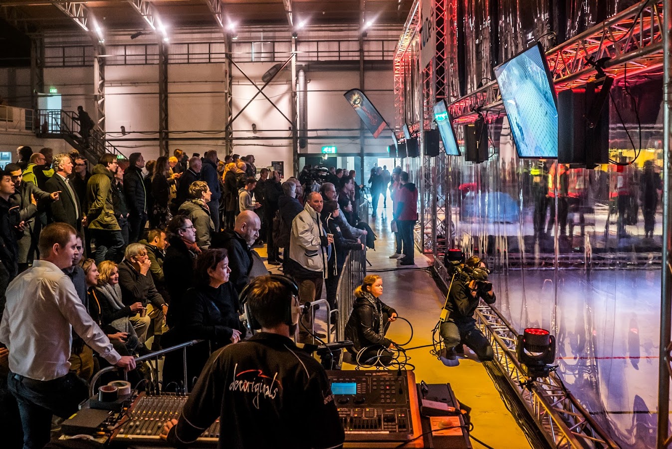
The drones soared, most weapons fired, many queens were taken down, and all battles have been fought. DroneClash has happened!

DroneClash is, and always has been, a multi-angle experiment. “I want to get the tinkering back into drones, I want to have fun with drones again, indeed I want to give the counter-drone industry a push with some unexpected views. And maybe I wanted to see if the authorities would allow us to clash drones, all in the name of science of course.” says Kevin van Hecke, co-organizer of DroneClash.

Well, we succeeded in that mission. And then some.

First: a call for new teams! DroneClash 2 is already coming up end of this year! Go here for team and subscription info. Not sure yet why you would want to join? Read below for what happened the first edition.

Battling

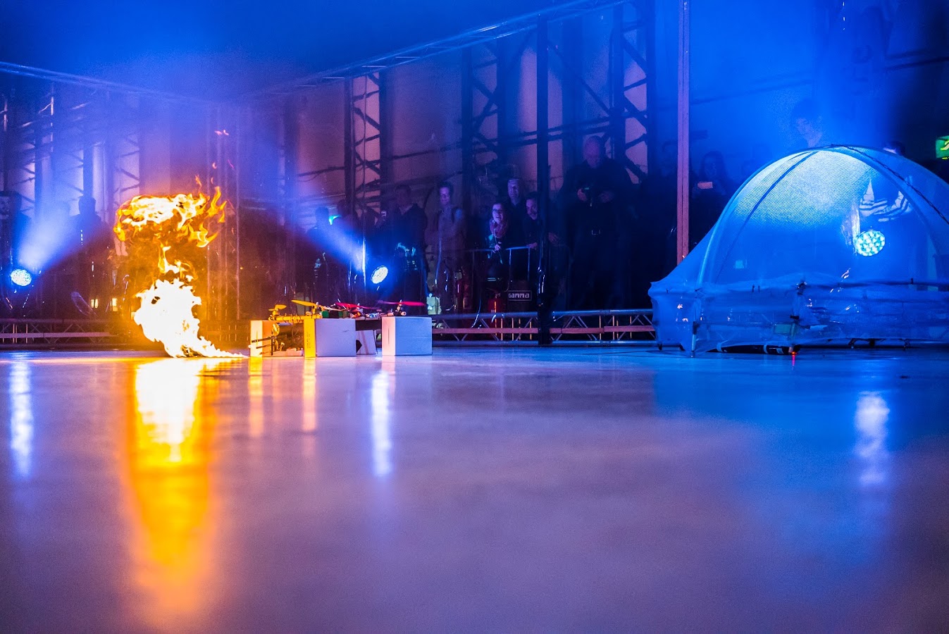
For those that aren’t clear on it yet, a quick rundown. Each team starts with at least two drones: a Fighter and a Queen. Each team can have multiple Fighters, as well as additional Queen Defenders. The goal is to have your fighters take down the rival queen. Additional points are awarded by hitting, grounding, or capturing other drones. In between the Fighter arena and the Queen arena lies the Hallway of Doom Death & Destruction, in which we placed counter-drone systems.

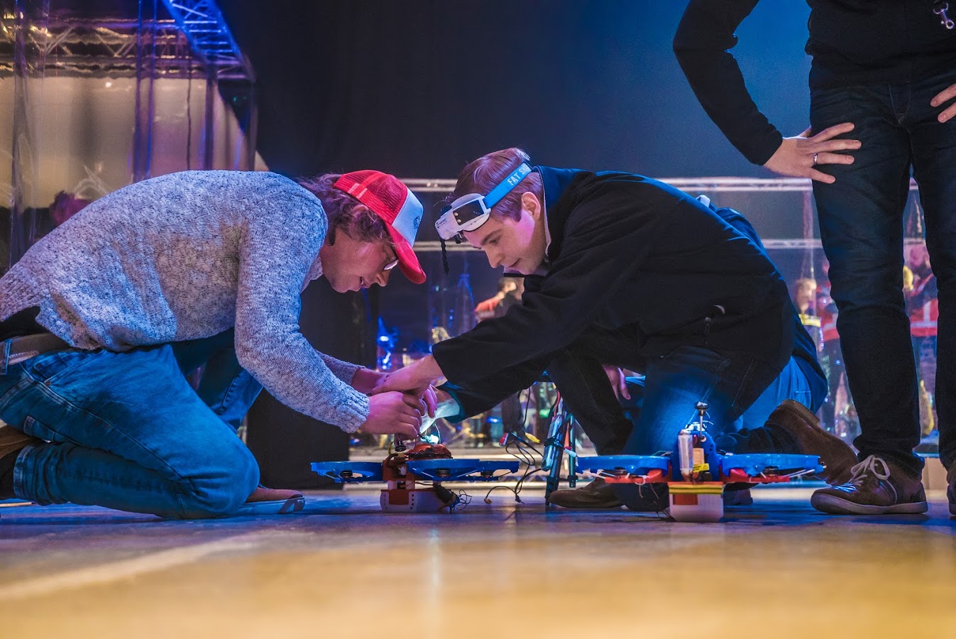
The first battle was the Laced Horns versus DeceptiDrones. Gadgets versus skills, flashy colors vs stealth. Countdown… Start! The first battle was away. The fighters from the Laced Horns were fast. Very fast. Without hesitation they left the DeceptiDrone fighters in their own dust and headed to the Hallway. Before anyone realized it, the Laced Horns shot through and arrived in the Queen Arena. They hit the DeceptiDrone queen hard, it did not stand a chance. It was over in less than 30 seconds, with a clear win for the Laced Horns.

DC 155

This set of events would turn out to be a recurring theme for the Laced Horns. “Skills and speed, just as we thought it would”, an ecstatic Geert Fokkema shouts, team captain of the Laced Horns.

“Actually, no one really knew what to expect. It showed in the first round of battles, gadget-teams that fought against fast or skilled piloted teams were unmatched and sometimes over in mere seconds. We expected the queen take-down to be a very hard task, it wasn’t. We expected that too many drones would fall victim in the Hallway of Doom Death & Destruction, at the hand of the counter-drone measures conspicuously put there. In reality none them were even scratched” says Bart Remes, co-organizer of DroneClash.

Hacking

Food for thought, also for the counter-drone industry. One of the questions we’ve answered many times: what did actually come out of DroneClash in terms of value for the industry? It’s a question also asked by the Ministry of Security and Justice, partner of DroneClash. Well, obviously the drones were all but impervious to our own counter-measures in the Hallway. It turns out that the drones used in DroneClash, some of them not that unrelated to ‘normal’ race-drones, have little to fear from blinding stroboscopes, thick smoke, or even a handheld net-cannon. Too fast, too small, too strong. A lesson in itself.

There were other outcomes too. Most notably, a novel technology was developed by one of our teams FBC2T, the letters being the letters of their first names. This team was another gadget team pur sang, they had developed two huge drones which they packed with everything they could think of. Confetti cannons, flamethrowers, paintball guns, you name it. But actually, their most important weapon was not in the arena, but just besides it. They had employed a hacker, who was able to do a highly intelligent attack on the control signals of the rival drones. In theory, given enough time, the team could overtake controls of any enemy drone. In practice, things were simplified: the plan was to just land them.

DC 063

Innovation and luck…

“There is theory, there is practice, and there are DroneClash battles”, says Amber Marijs co-organizer of DroneClash. In the chaotic aftermath of the first battle, FBC2T and A3T had to quickly set up their drones for the next battle. FBC2T struggled to get their enormous drones in place, and in the process some of the complex electronics got intertwined with the complex software. It unknowingly changed the ID of their Fighter. It caused them to inadvertently hack their own drone with the new ID. They did however also hack the enemy fighters, for this they gained points. The concept was proven!

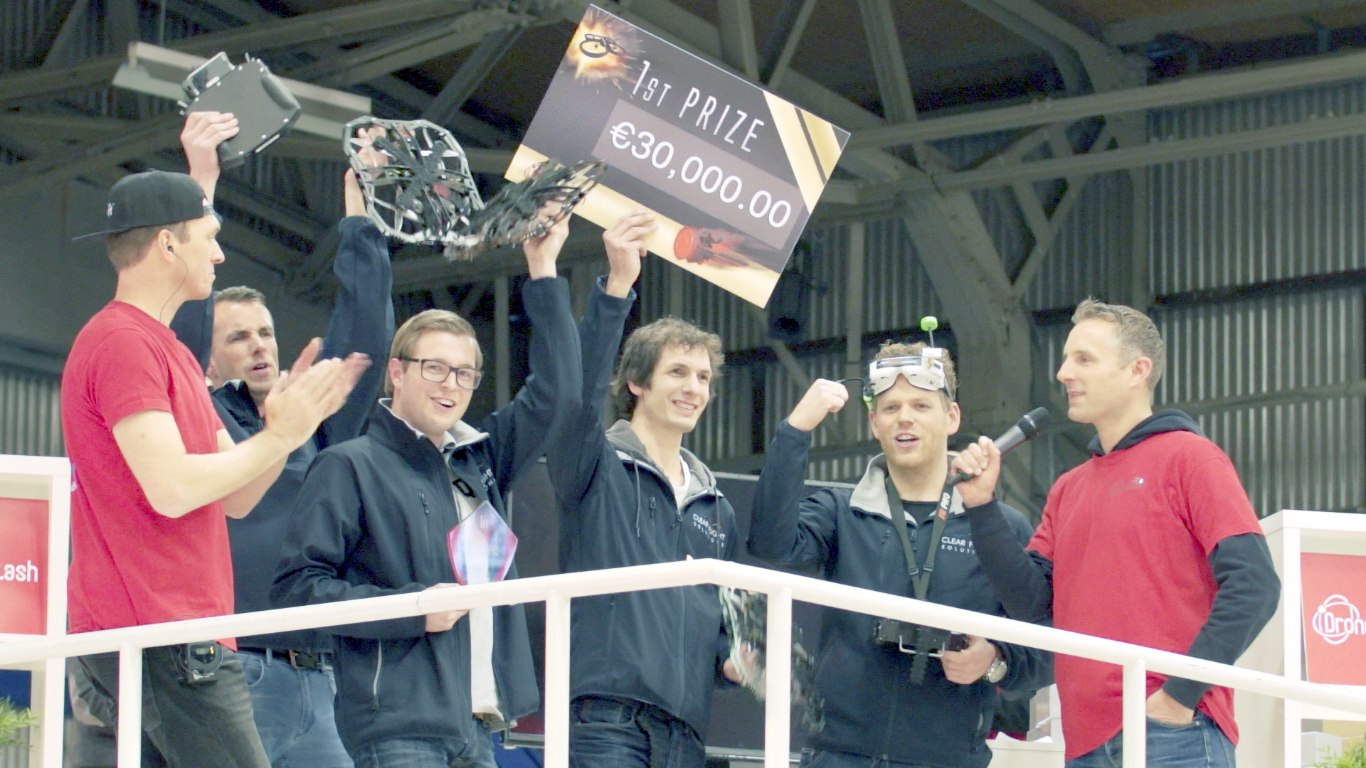
FBC2T’s hacking is an amazing feat, more so because this is potentially a legal way to both detect and counter a drone. The team was awarded the Innovation Award by the jury.

DC 158

In their next battle, against the Laced Horns disaster struck for FBC2T. Although they implemented hacking for all most used protocols, the Laced Horns used another protocol. FBC2T knew that for this battle they would have to change their strategy. The last-minute changes, the time pressure, the little sleep. It caused them to rush things. The countdown started anyway. Start! Laced Horns soared off. FBC2T fired their weapons, but nothing happened. The Laced Horns did not wait around, and quickly finished the job in another spectacular combination of speed, skills, and force. Even against a blue ‘jellyfish’ drone 10 times their size.

22

Drones will Clash again!

Do you want to have extreme fun with drones? Fit them with all kinds of crazy gadgets, or just make them too fast to see and close to indestructable? For a good cause? We are looking for (international) teams again! Go here for info.

Read more…

3689729214?profile=original

Hi guys,

As promised, here is the next and so-far final episode in our autopilot precision series. In this series of videos and articles we test multiple drone autopilots in terms of precision by flying them on a simple (yet often typical) photogrammetry route created in UgCS mission planning software. The flight trajectory of each drone is compared against the ideal test route.

In this final part we look at the results of DJI M600. Next week we will publish a table containing the overall results comparing all autopilots and the average deviation each of them had from the test route.


See the results for DJI M600 in the video below:

Download the KML files and take a look at them yourself in Google Earth:
https://www.ugcs.com/en/page/comparing-precision-of-autopilots-for-...

Get the newest version of UgCS here:
https://www.ugcs.com

Safe flights,
UgCS Team

Read more…