All Posts (11086)

Sort by

3689586785?profile=original

UAV Safety Story

From ABC News Australia

Aviation authorities are struggling to keep up with a boom in remote controlled drones over Australia's cities.

The Civil Aviation Safety Authority (CASA) has issued warnings to more than 100 users for safety breaches and is now scrambling to roll out a public awareness campaign.

A number of safety scares including an incident involving an athlete and a drone in Western Australia have underscored demands from some within the industry for tougher regulations.

Raija Ogden was competing in a triathlon in Geraldton when she says she was hit by a drone.

She has backed demands for better controls.

"I agree that there should be better enforcement of regulations and more appropriate penalties for breaches," she said.

The rules appear to be poorly understood among amateurs in particular.

Remote controlled drones can be bought relatively cheaply from mainstream retailers or online but they do not come with any information about how to fly safely.

CASA now plans to ask retailers to hand out leaflets explaining the regulations.

Drones cannot be flown within 30 metres of cars, buildings or people; at night; or above 400 feet.

Read more…

3689586771?profile=original

Hi guys, previously I posted a description about my Ground station.

Since than, I spent many hours on testing and flying with it!

Regarding my experiences, I came up with a 2.0 design, which could be really a multifunctional, easy-to-use device for many multirotor/UAV pilots.


First of all, the basic connection diagram can be found at the beginning of this blog entry.My vision is to use a 10” Android tablet, and have a special bay for it. Also, the three RF modules (RC module, Video receiver and telemetry) should have been detachable modules, to let user replace them with another ones. And also let the road open for later development on them.

Here are the short descriptions for the detachable module parts:

1) RC range

I think the radio part has to be as simple as it can, to avoid any malfunctions in basic RC handling. My idea is to design a simple core (ie. in Arduino) which runs the program that handles the sticks, trim buttons and switches/pots, generates PPM for RF module, but has not any screen or input keys. All the programming part could be done by the Android tablet connected via FTDI, with a special app – or the ground station app. Maybe some of the open-source Transmitter develpoments could be used as basic….? Since it would be modular, many kind of RF modules (433 LRS, 2.4 GHz FHSS, etc...) could be used later.

 2) Video range

I see some interesting test videos about UVC video interfaces, which have native driver support in android 4.3+! FEBON makes great UVC products, so maybe these could be used, and latency could be reduced for FPV specific purposes, if FEBON looks enough fantasy and/or market in FPV. My vision is that Droidplanner app should handle live video feed, for example use it as a background in a graphical HUD-like view (so OSD would be not neccessary anymore). Since it would be modular, both HDMI or RCA video receivers could be built in to different modules, let user upgrade the video quality later (I hope HDMI video systems will be cheaper soon), or have multiple video modules for different setups and replace them on field.

 3) telemetry range

Both 3DR or higher range telemetry modules could be used, in changeable modules.

I think the adoreable work of Arthur and the developer team of Droidplanner could be use as a basic for this device. Some new functions should be developed (ie. background from video feed, setup interface for RC core, and many minor updates).


If anybody interests in this project and would like to invest in or has some ideas, just contact me via nhadrian@gmail.com. But I’d be the happiest if 3DR and/or the Droidplanner team would be interested in, since their work would the basic for many parts (ie. Droidplanner itself…)


I’m good in 3D designing but not qualified enough for PCB design/programming. So what I can offer is to make 3D design and perhaps moulds for later injection moulding, or give support in them. Also I have contacts for 3D printing and milling for plate productions. I would not get any single coin for my work, just enough parts to build one GS for myself...


Some more thoughts…

I think the construction type I used in GS1.0 works great and could be used (composite plates and plastic sidewalls and spacers). Also the Li-ion battery I used works great, 6600 mA looks enough for contionous usage. But I think there must have the opportunity to connect external 12V source during operation and perhaps have a small charger circuit that charges the internal Li-ion battery if external source has enough amperage.

Regarding tablet, we should find the best tablet for this purpose, which has good-positioned USB socket, the factory firmware can handle all functions that we need, has enough screen brightness/quality for outdoor operation and not the most expensive on the market…

Also some tests should be made if Droidplanner can handle two FTDIs and one UVC interface connected to an USB hub at a time.

About modules, I think some fast-release design should have been made, with quite universal connectors at the end, so any kind of devices could be inserted into the module housing. Antennas and/or external antenna connectors (ie. for tracking antenna systems) have to be on the modules end.


Best regards

Adrian

Read more…

NAVIO: RTK demonstration

Hey guys, we wanted to share a visual demonstration of  RTK GPS.  The demo was made with NAVIO board and Raspberry Pi running RTKLIB. Plots display how RTK GPS solution compares to a single GPS solution from the same receiver.

RTK is a type of differential GPS where two receivers are used - one is stationary and acts as reference station by calculating corrections and sending them to another receiver - rover, that can apply those corrections and increase the accuracy of coordinates.

Corrections in RTK are calculated based on carrier phase measurements and resulting coordinates can be accurate to millimeters. But unlike code cycles, phase cycles are indistinguishable and that creates a problem of integer ambiguity.

In RTK terminology there are different types of solutions:

  • Fix (green on plots) - Solution with fixed integer ambiguity (centimeter accurate).

  • Float (yellow) - Integer ambiguity is not fixed (accuracy floats, may be decimeters).

  • Single (red) - No differential corrections applied (meters accuracy).

RTK is a well-known technology in the field of geodetics, but commercial systems could cost a fortune.

NAVIO is equipped with a special version of u-blox NEO6 receiver - NEO6-T, which outputs raw GPS measurements. And as RTK is differential GPS - two receivers should be used, but one of them could be replaced by corrections from the internet.

We have conducted several tests with NAVIO boards. The antenna was placed on the roof of a vehicle and kept static. 


Navio-GPS-RTK-vs-Single-Point-Fix-e1397594760389.png

After that it was driven in a circular path.
Navio-GPS-RTK-vs-Single-Circle-Fix.png


RTK is an advanced feature and multiple factors influence quality of the solution - antenna, RF interference, satellite visibility. To keep track of the latter, we usually check ourselves with SatPredictor tool before going to the field. It creates a nice plot with quantity of visible satellites based on your area, date and elevation mask (common rule is to set it to 15deg).

Navio-GPS-RTK-vs-Single-SatPredictor.png

We have different antennas, but usually use Tallysman dual-feed patch as it has very low noise figure and high gain. A rule of a thumb for good RTK performance is to have several satellites with SNR (signal/noise ratio) around 50. A good idea is to have the base permanently installed on the roof of your home or on the roof of club building at the field and broadcast corrections over 3G. This way you can share the base station with your friends and colleagues. Permanent installation would result in a more reliable and predictable satellite visibility. In some areas RTK corrections are already available from universities or other organizations, search for NTRIP servers nearby.


P.S. By the way, float solution does not mean bad solution.


Navio-GPS-RTK-vs-Single-Circle-Float-does-not-mean-inaccurate.png


We’ll post a tutorial how to set up RTKLIB soon, you can subscribe to our blog emlid.com or follow us on twitter to stay informed.


Read more…
3D Robotics

From the Associated Press:

Kele-Stanley.jpg?resize=199%2C300&width=199

SPRINGFIELD, Ohio (AP) — A man is facing charges after deputies say he was flying a video camera-equipped drone that hindered the landing of a medical helicopter at an accident scene.

Kele Stanley, of Springfield, said he’s been unfairly charged and would have landed it immediately if he knew the medical helicopter was en route.

“I’m not an idiot,” he said.

The hobbyist was flying the $4,000 drone over a crash scene on Saturday morning to shoot photos and video.

Authorities said both fire officials and a Clark County sheriff’s deputy told Stanley to stop flying his remote-controlled aircraft because the helicopter was preparing to land, and that he refused. The helicopter was able to land and depart safely from the scene.

Stanley is facing a felony charge of obstructing official business and misdemeanor charges of misconduct at an emergency and disorderly conduct. He pleaded not guilty during a court appearance Monday and said he’s going to hire a lawyer to fight the charges.

Stanley, a 31-year-old copy-machine repairman and videographer, said he flew his remote-controlled “hexacopter” about 75 feet above where a pickup had hit a tree in Moorefield Township near Springfield. He said he was shooting the video as a hobby and would have turned it over to local television stations, as he has done before.

There currently are no regulations in Ohio governing private use of the unmanned aircraft, although law enforcement agencies must get special permits to use them. The Federal Aviation Administration bars the commercial use of drones.

(Photo above: Clark County Jail)

((Photo below:/Clark County Sheriff's Office)

3689586751?profile=original

Read more…
Moderator

ArduPilot formation flying revisited

Further to our first attempts at fully automated formation flying (see http://diydrones.com/profiles/blogs/ardupilot-formation-flying-attempt), Phil (http://diydrones.com/profile/PhilRudram) with his rebuilt Valdez (v2) and I headed out to try again.

Most of the flights were really good with the two planes following the route (and each other) very well. The turns especially were almost mirror images of each other and watching the two planes from the ground flying in almost perfect formation was amazing.

The first afternoon was really calm and this benefited both planes a lot. Each flight lasted around 25 minutes.

On the first day we tried a triangular course with waypoints around 700m (2300ft) apart but on the second day the course was set rectangular with the long legs around 1200m (3930ft) apart. The wind however had picked up a bit and was a bit lumpy with thermals starting to build.

We took about 2 hours of onboard video with a Mobius camera and a bit of ground video, but due to the wide-ish angle of the Mobius' lens the lead plane was often quite small although they looked really close at times both from the ground and from the FPV video setup on my plane.

All went very well until... not unexpectedly - a midair collision!

See the video for details.

Read more…
3D Robotics

3689586807?profile=originalThanks to Chris Crews in the forums, a new AeroCore from Gumstix. $199

The AeroCore from Gumstix offers everyone from enthusiasts to educators the opportunity to power their very own micro-aerial vehicle. With an ARM Cortex-M4 microcontroller running NuttX RTOS and an integrated connection for award-winning DuoVero series computers-on-module, AeroCore gives users a complete Linux installation on a PX4-compatible platform.

2 x 70-pin Hirose DF40 Connectors

70-pin Hirose DF40 Connectors (Expansion side)

24-Pin Header

8xPWM Outputs

40-pin header

GPIO/Breakout and Power

6-Pin Header

Cortex-M4 SPI Breakout

Accelerometer

3-Axis Accelerometer + 3-Axis Magnetometer

Barometer

Included

Gyroscope

3-Axis Angular Rate Sensor

Processor

ARM Cortex-M4 Microcontroller

USB OTG

USB Micro-AB Connector

Andrew Simpson from Gumstix adds some details in the comments:

I work at Gumstix and the AeroCore is so new that it won't even be officially announced until tomorrow morning!

The AeroCore is a DuoVero expansion board that can also be used standalone; the onboard microcontroller is the same as the one on the PX4FMU (STM32F4 series Cortex-M4), but some of the sensors are different (full tech. specs here).

I'm not very familiar (read: not at all!) with ArduPilot/APM and AP-HAL software, but I'm sure it can be made to work on the AeroCore with a little bit of effort. We're hoping the AeroCore will be a good choice for developers who want to do some interesting, high-level stuff in the air.

Thanks! Let us know if you've got more questions!

Andrew Simpson
Content Developer
Gumstix, Inc.

Read more…
3D Robotics

3689586545?profile=original

From TechCrunch:

Google has acquired Titan Aerospace, the drone startup that makes high-flying robots which was previously scoped by Facebook as a potential acquisition target (as first reported by TechCrunch), the WSJ reports. The details of the purchase weren’t disclosed, but the deal comes after Facebook disclosed its own purchase of a Titan Aerospace competitor in U.K.-based Ascenta for its globe-spanning Internet plans.

Both Ascenta and Titan Aerospace are in the business of high altitude drones, which cruise nearer the edge of the earth’s atmosphere and provide tech that could be integral to blanketing the globe in cheap, omnipresent Internet connectivity to help bring remote areas online. According to the WSJ, Google will be using Titan Aerospace’s expertise and tech to contribute to Project Loon, the balloon-based remote Internet delivery project it’s currently working on along these lines.

That’s not all the Titan drones can help Google with, however. The company’s robots also take high-quality images in real-time that could help with Maps initiatives, as well as contribute to things like “disaster relief” and addressing “deforestation,” a Google spokesperson tells WSJ. The main goal, however, is likely spreading the potential reach of Google and its network, which is Facebook’s aim, too. When you saturate your market and you’re among the world’s most wealthy companies, you don’t got into maintenance mode; you build new ones.

As for why an exit to Google looked appealing to a company like Titan, Sarah Perez outlines how Titan had sparked early interest from VCs thanks to its massive drones, which were capable of flying at a reported altitude of 65,000 feet for up to three years, but how there was also a lot of risk involved that would’ve made finding sustained investment while remaining independent difficult.

Read more…

DIY Monocopters

3689586463?profile=originalHi guys,

I'm a new member in the DIYDrones family, and this is my first blog post sharing some of the monocopters that I've built as a hobby project.

I started making my own monocopters back in 2011 after watching the inspiring work on monocopters from University of Maryland, Lockheed Martin and ERAU. I was fascinated with the way the monocopter flies without a fixed heading and yet controllable. So I started trying to make one out of some small and cheap parts I could find at that time, using the UMD design as a reference.

3689586505?profile=original

I was kind of surprised at that time that it managed to take off. Here's a video that I took:


Excited with the result, I immediately began to work on the control. With great help from the 2008 MIT paper "Fly-by-wire Control of a Monocopter" by James Houghton and Woody Hoburg, I tried to implement the equations presented in the paper into Arduino code.

The microcontroller chosen was Teensy 2.0 for its relatively small size. MicroMag 2 was used as the sensor for heading reference and a LPY5150AL was used for RPM sensing. Here are some photos of the board I made to house the electronics:

3689586393?profile=original3689586628?profile=original
The motor used was Turnigy 1400 Brushless Indoor Motor 4500kv paired with a small 6 Amp ESC. Props used is GWS EP-3030 and battery is 2S 450mAH LiPo. Receiver used was FrSky D4R-II with PPM output and MKS DS480 was chosen for its speed. 

The construction of the frame was improved by utilizing Carbon Fibre sheets, built in a way very similar to the UMD prototype. Electronic components are mostly secured with heat shrink tubes and the motor is mounted on a square aluminium tube which is secured to the carbon fibre frame with screws. Some photos of the final build:

3689586569?profile=original3689586531?profile=originalHere's a video of the first successful controlled flight indoor:


Here's another video of indoor flight:


The prototype weighs 90 grams and hovers for around 5-7 minutes.

After the first successful prototype I wanted to add more sensors but was limited by the lack of space for more electronics. So this time I tried to make another prototype with Lockheed Martin's design.

A 3D model of the wing and body of the new prototype was created with SolidWorks and subsequently printed using the SLS 3D Printer, Formiga P100 in the Fabrication Lab in SUTD. Here's a SolidWorks render and some photos of the assembled prototype:

3689586653?profile=original3689586595?profile=original3689586679?profile=originalA RGB LED Module that I got from a friend is included in this prototype for some POV coolness.

Here's a video of the second prototype:


As of now a monocopter, except for its cool factor, has not much of a use.

However I hope my post will be helpful for those looking to make one of this fascinating little fliers :)

Read more…

3D-printed drone parts

I have 3d printed a wing part has been flight tested with a MULTIPLEX fuselage (above)

Now I am in a fuselage designing process and I am not sure in the printer axis parts since airstream aligned to Z printer axis layers.

Could somebody help me?

Thank you

Read more…
3D Robotics

3689586448?profile=original

In Forbes, aviation expert John Goglia (at right) analyzes the FAA's appeal in the the "Trappy" case. 

In an indication that the FAA is not going to give up on its test case against Raphael Pirker for operating a small drone in the vicinity of the University of Virginia, the FAA filed its brief specifying the legal bases for its appeal of the National Transportation Safety Board judge’s decision dismissing the FAA’s $10,000 civil penalty.  The appeal will be decided by the Board’s Members who are charged with reviewing appeals of FAA cases. 

The FAA raises two issues in its brief: 1. that the judge erred in determining that Pirker’s small drone was not an “aircraft”, as defined by the Federal Aviation Regulations (FARs) and 2. that the judge erred in determining that the small drone’s operation was not subject to the FARs.

The FAA’s arguments are familiar to many who have been following this case.  The FAA believes that drones or unmanned aircraft systems (its preferred term) are aircraft and that as aircraft are subject to the requirements of federal regulations, including the requirement that aircraft not be “operated in a careless or reckless manner so as to endanger the life or property of another.”  The FAA contends in its brief that the NTSB judge was wrong to conclude that Mr. Pirker’s drone was a model aircraft and that the FAA had effectively waived any right to enforce its rules against model aircraft operators, regardless of whether they are operated as a hobby or for commercial purposes.

While the FAA claims that Mr. Pirker’s drone was an aircraft and that he acted as pilot-in-command when he was not licensed, the FAA does not charge him with violations related to the drone’s lack of certification or his lack of a pilot’s license.  The FAA’s sole charge against Mr. Pirker is careless or reckless operation of an aircraft.

As a Board Member for almost ten years, I reviewed hundreds of appeals of FAA cases against pilots and mechanics.  Most often, the FAA’s cases were properly brought and the legal and factual bases were appropriate and I would vote to sustain the FAA’s position.  On occasion, the FAA’s legal arguments defied logic and I would vote to reverse the action.  This case appears to me to be one that defies logic.  How can the FAA suddenly claim that a small unmanned aerial vehicle is an aircraft when for decades it has allowed them to be operated – albeit under the term “model aircraft” – without complying with any of the regulatory requirements for aircraft, such as type certificates, airworthiness certificates, maintenance requirements, pilot licenses and so on? 

The distinction the FAA has made between commercial and non-commercial when it comes to the operation of model aircraft doesn’t make sense to me, when the issue is really whether they are aircraft at all. That being said, I am concerned with the manner in which this drone was allegedly operated, especially if it was operated too close to people or property.  But even if the drone’s operation was unsafe, unless that operation is covered by a rule, FAA enforcement would be inappropriate.

Since I’m not a lawyer, I checked with Loretta Alkalay, former top attorney for the FAA in New York and an adjunct professor at Vaughn College of Aeronautics (where we co-teach) what she thought of the FAA’s legal arguments.  This is her response:

“The FAA clearly has the statutory authority to regulate commercial unmanned aerial vehicles of any size. (Congress recently took away the FAA’s authority to regulate model aircraft operated for hobby or recreational purposes.)  The question is whether it has properly promulgated regulations to do so.  I do not believe it has when it comes to small UAVs to the extent that they can be considered model aircraft, as in the case of Mr. Pirker’s.  Although I am sympathetic to the FAA wanting to prohibit unsafe operation of these aerial vehicles that may endanger persons or property – as it clearly believes was the case here- it has to do so via properly enacted regulations. 

Unfortunately, the FAA created its own legal confusion by relying on advisory (as opposed to regulatory) methods for distinguishing model aircraft (which could include the small drone operated by Mr. Pirker) from other aircraft beginning in 1981.  Its attempt to retroactively distinguish model aircraft based on the nature of their operations (commercial vs. non-commercial) is unenforceable as that distinction has only been made via public notices (first starting in 2007) and not by  rulemaking.  Since notices are not rules, they are legally unenforceable.

Fortunately, the remedy for the problem created by the FAA also lies with the FAA.  And that is to issue legally promulgated rules to cover small, commercially-operated drones.”

It seems to me that it would be a better expenditure of FAA time and resources to focus on issuing regulations allowing the safe operation of small commercial drones than continuing this case against Mr. Pirker.

Read more…

dji-kittila.png?width=550

A few days ago, I already wrote an article about our "Apple of the drone manufacturers", DJI and it's new no-fly zones. Now it's time to have a little more detailed look at their idea.

What DJI did was introduce no-fly zones of 8km (5 miles) around "major airports". I already noted, that their list includes "major" airports, such as Kuusamo, Finland (population 16177), Kittilä, Finland (population 6315) and even the closed and not even usable as emergency landing site due to used car lots on the runway, Raadi airfield at Tartu, Estonia.

Here is now a look at Finland and the impact of those no-fly zones (I couldn't resist to include Tartu, Estonia too). Finland is just an example for the consequences . In essence, especially in smaller towns with regional or local airfields which have only minimal movement and very often are used by local RC-clubs at the weekends, not only the (legal) use of the airfield is impossible but due to the unreasonable large zone, basically, operation in the whole town isn't possible.

Read the full article: http://stefan.gofferje.net/uav/195-a-closer-look-at-dji-s-new-no-fly-zones

Update:

I have removed the total block of Apple devices from my website for now after Chris told me that about 1/4 of all DIYD users actually are on Apple. I did remove it to prevent backfire and unrest at DIYD, not because I think, it's wrong!

Here is a video from DJI explaining the system in detail:

Read more…

Dsky.jpg?width=512

According to news Nasa is releasing the source code of more than 1000 software "The software that the agency has developed over years cover things like image processing, robotics, data processing, and design tools amongst other things.". I think those softwares belongs to old Apollo, Mercury or Gemini missions. It would be very cool to see the code of P61(program 61 used to land the lunar module to the surface of the moon). 

We can also grab a lot of useful piece of code for our APM or Pixhawk firmware. 

Read more…
3D Robotics

FAA vs Search-and-Rescue drones

MtnDeployment-1397242582620.jpg

From IEEE Spectrum:

Gene Robinson of Wimberly, Texas, is a licensed pilot and also flies radio-controlled model airplanes—not an unusual combination. About a decade ago, he realized that a model aircraft outfitted to take aerial photos could be enormously useful in locating people who have gone missing—perhaps because they’ve been abducted or maybe just because they are very young and have wandered off into the woods alone. His efforts have paid valuable dividends over the years— helping find the remains of nearly a dozen people. But since late February his search-and-rescue model airplanes have been grounded: That’s when the Federal Aviation Administration notified him in writing that what he has been doing is illegal.

Since 2007, the FAA has maintained that model airplanes, no matter how small, cannot be flown for commercial purposes until the agency puts regulations in place to accommodate them. But thousands of people fly radio-controlled (RC) model airplanes as a hobby, and what Robinson has been doing with his 2-kilogram, electrically powered, foam-and-plastic planes is really no different. “This is a double standard we’ve had to deal with for almost seven years,” says Robinson.

Ostensibly, the FAA’s concern is safety. But Robinson is more careful than most RC modelers, following strict procedural guidelines and taking care always to coordinate his flights with the local authorities on the scene. So it’s difficult to argue that his flights are more dangerous than what goes on every weekend at RC modeling sites throughout the United States, which can include flights of huge models that weigh 10 times as much as Robinson’s planes; aerial stunts of nitromethane-fueled model helicopters; and the low-altitude, 500-kilometer-per-hour passes in front of spectators of model jets powered by miniature turbine engines.

The FAA’s objection here is that Robinson is violating its ban on commercial drone flights. But Robinson takes no money from the families seeking their lost loved ones, and he has created a not-for-profit organization, RP Search Services, to demonstrate that he is not running a money-making operation. He works closely with Texas EquuSearch, another not-for-profit organization that originally enlisted volunteers on horseback to find people who had gone missing in the wilderness and now helps direct volunteer searchers who have many different kinds of skills and specialty equipment to contribute to the effort.

Since 2006, aerial photos taken with Robinson’s models have helped EquuSearch volunteers to avoid hazards on the ground as they comb the wilderness. And his images have been instrumental in locating the remains of 11 people who were killed or succumbed to the elements while missing, helping to bring closure to their distraught families.

FAA officials have long been aware of Robinson model airplane flights and have expressed their displeasure to him verbally at various times since 2007, when the FAA first established its ban on the commercial use of model airplanes. But it was only this past February that an official stated the FAA’s position in writing, telling Robinson in an email message to “stop immediately. That is an illegal operation regardless if it is below 400ft AGL [above ground level], VLOS [visual line of sight] or doing volunteer SAR [search and rescue].”

At that point, Robinson and Tim Miller, founder of Texas EquuSearch, approached Brendan Schulman, a special counsel with the law firm Kramer, Levin, Naftalis & Frankel, who offered pro bono help. Schulman, an RC modeler himself, had recently succeeded in getting a favorable court ruling for Raphael Pirker, another RC modeler the FAA held to be violating its regulations. “It is incomprehensible that the FAA would for decades raise no issue with respect to recreational operation of these devices but prohibit and deem ‘illegal’ the exact same use for the purpose of saving the lives of missing children,” Schulman wrote on 17 March to the FAA chief counsel in a lengthy argument on behalf of his clients.

Schulman’s letter asks the FAA to reverse its position within 30 days. “I wanted to give them time to think it over,” says Schulman. “On the other hand, there are people every week who need help.” In the meantime, Schulman has advised Robinson not to fly his models on any more search-and-rescue missions. “We’ve made the painful decision to hold off on some searches,” says Robinson. “We’re gritting our teeth.”

Even if the FAA refuses to change its position in the near term, it’s possible that when it finally does issue its long-awaited rules for “small unmanned aerial systems,” things could change. The new rules might well make it legal for volunteers like Robinson to use camera- or sensor-equipped model airplanes in searches for people who have gone missing.

...

Read more here

Read more…
3D Robotics

Insanely big multicopter (?) lifts off

3689586341?profile=original

No video, sadly. From Gizmag:

Following on from driving tests that wound up in December last year, the Black Knight Transformer prototype demonstrator has taken to the air for the first time. California-based Advanced Tactics, Inc., announced its vehicle, which combines the capabilities of a helicopter and an off-road vehicle, completed its first flight tests last month, being remotely piloted at an undisclosed location in Southern California.

During the test flights, the vehicle's stability and attitude were handled by the autopilot, with the ground-based human pilot only responsible for increasing or decreasing power. Although it is designed to hover at altitudes of up to 10,000 ft (3,050 m), for safety purposes altitude was limited to less than 10 ft (3 m), with outrigger landing gear attached to prevent it rolling over in the event of any mishaps. There was also an electrical cable attached to the underside of the vehicle that provided emergency shutdown capability. Turns out these precautions weren't required, with Advanced Tactics reporting the aircraft was stable, controllable, and performed as expected.

Similar to the aircraft being pursued by DARPA's Aerial Reconfigurable Embedded System (ARES) program, the Black Knight is designed specifically for autonomous casualty evacuation and unmanned cargo resupply missions. While it can be flown by an onboard pilot, its unmanned capabilities are intended to keep pilots out of harm's way on dangerous missions.

The Black Knight Transformer during its first flight

The vehicle boasts six rotors, with a high-speed computerized feedback control system managing the differential thrust between opposing sets of prop-rotors to provide stability and control. This is similar to the approach employed by small electric multicopters, with the company saying this approach is mechanically simpler and cheaper than employing an articulated rotor system like that found on conventional helicopters. This also eliminates the need for a tail-rotor or engine transmission.

To strengthen its suitability for military cargo resupply missions, the vehicle's design provides it with a large interior volume relative to its overall footprint. The company says this feature also makes it suitable for civil missions, such as package delivery and fire-fighting. Measuring 31 x 19 x 8 ft (9.5 x 5.8 x 2.5 m)(L x W x H) in flight configuration, the prototype demonstrator weighs 4,400 lb (1,995 kg).

The AT Black Knight Transformer has a large interior volume similar to that of a BlackHawk...

On the ground, it can reach speeds of 70 mph (112 km/h) traveling on suspension and a drivetrain similar to those found in off-road trucks. As well as smoothing out the ride on rough terrain, the large truck tires and shocks also help soften the vehicle's landings. The modular automobile portion of the vehicle is also designed to be removed to allow for additional payload capacity, or swapped out for a boat hull or amphibious hull for water operations.

Advanced Tactics says that the successful first flight test of the Black Knight Transformer will pave the way for other future modular and roadable vertical takeoff and landing (VTOL) aircraft. The company has been working on the smaller AT Panther Transformer, a "low-cost vehicle" that carries two passengers and their gear and is designed for Special Operations missions. It is also developing a modular, cargo carrying aircraft that would carry 3,500-lb (1,590-kg) payloads in detachable cargo pods. The company is currently seeking investors and pursuing US and other government commercial opportunities.

Source: Advanced Tactics, Inc.

Read more…
3D Robotics

Long-range (40 mile!) RC control project

3689586355?profile=originalFrom Hackaday:

Long range wireless control of a project is always a challenge. [Mike] and his team were looking to extend the range of their current RC setup for a UAV project, and decided on a pair of Arduino mini’s and somewhat expensive Digi Xtend 900Mhz modems to do the trick. With a range of 40 miles, the 1 watt transceivers provide fantastic range. And paired with the all too familiar Arduino, you’ve got yourself an easy long range link.

[Mike] set the transmitter up so it can plug directly into any RC controller training port, decoding the incoming signal and converting it into a serial data package for transmitting. While they don’t provide the range of other RF transmitters we’ve seen, the 40 mile range of the modem’s are more than enough for most projects, including High Altitude Balloonmissions.

The code for the Arduino transmitter and receiver sides is available at their github. Though there is no built-in error correction in the code, they have not had any issues.  Unfortunately, a schematic was not provided, but you should be able to get enough information from the images and datasheets to construct a working link.

Read more…

nmsubt4

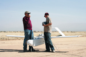
Neat story. I am the BAT 4 External pilot for the mentioned flights. I am holding the R/C controller: Very interesting study. Take a look.

Video: 

https://www.youtube.com/watch?v=eYu9N17U8dg

"Unmanned aircraft aids NMSU Ag research

By Emily C. Kelley

LAS CRUCES, N.M. >> A small group of researchers and technicians recently gathered on a dirt airstrip at the USDA Jornada Experimental Range to launch a Bat 4 unmanned aircraft on a mission, flying through both military restricted airspace and the National Airspace System.

“We do rangeland monitoring, and it’s a way to gauge rangeland health to see how the plants are doing over the course of the year,” said Connie Maxwell, USDA biological science technician and NMSU affiliated faculty member.

This specific flight is one of a series that will monitor plant growth cycles for a USDA scientist studying vegetation response to climate. The scientist selects the flight dates in conjunction with satellite over-flights to compare the images.

“We were doing an imagery flight,” said Maxwell. “We have several sites out on the Jornada that we do repeat imagery on. This was a baseline flight for the year, before things start growing. In a couple of months, we’ll go back and do the same flights we did that day, and see the green of the vegetation out there, and then later on in the year, we’ll see peak times – we’ll catch peak biomass, then at the end of the year when the plants start dying.”

The vegetation study is one of many that Maxwell and her colleague Amy Slaughter, USDA biological science technician and NMSU affiliated coordinator and graduate student, support with imagery from unmanned aircraft flights each year.

Each flight is the culmination of several weeks of work, determining the logistics of what the crew will do on flight day.

“As many times as we’ve done these flights, they’re never the same. There’s always some kind of a change, so you basically have to start from scratch,” Maxwell said. “We got a new airplane that we just started using last year, so basically, we have to redo everything because it’s a totally different system.”

The use of unmanned aircraft at the Jornada Range dates back to 2006.

The Bat 4, manufactured by the MLB Company, has a 13-foot wingspan. The smaller Bat 3 that Maxwell and Slaughter still occasionally use has a six-foot wingspan, but carries a much smaller payload. A payload is the total complement of equipment carried by the aircraft, in this case, cameras. The Bat 4 is able to carry a 20-pound payload of two cameras — a Canon SLR 21-megapixel camera and a Tetracam mini multi-camera array. With each Tetracam exposure, separate bands of visible or near-infrared radiation are captured by six camera lenses to form a separate, monochromatic image on each camera sensor. The images allow researchers to make several determinations about the depicted vegetation.

http://www.demingheadlight.com/deming-opinion/ci_25538216/unmanned-aircraft-aids-nmsu-ag-research"

Read more…

X-UAV Skua

3689586169?profile=original

X-UAV has released a new UAV platform called the Skua. I will try and get one for some review.

Wingspan: 2100mm
Length: 1150mm
Flying Weight: 2500g-3000g
WingArea:55d㎡
Wingload: 45~55g/d㎡
RECOMMEND DRIVE SYSTEM
Drive System: 3720 KV1200
Propeller: ≤10in
ESC: 60A
Servo:2*9g 2*17g servos
Battery: 14.8V, 4S Li-polymer
Control system: 4CH 2.4GHz Transmitte

3689586185?profile=original

3689586139?profile=original

3689586314?profile=original

3689586254?profile=original

Read more…

Maidened Y6 - what I looked for

3689586037?profile=originalJust a bit of a monologue about what I did on my maiden, and I what I looked for before I started flying it properly. Some people just go full sticks right after arming, but I prefer a more cautious approach.

Step 1: All the calibrations done - radio, compass, compassmot, flight modes etc. Importantly, only 3 flight modes configured - stabilise, alt hold and Loiter. RTL was temporarily replaced with autotune (more on this later). Laptop connected up for full telemetry.

Step 2: Armed, and spooled up to near hover; to test if it will take off in a stable manner. If it tried to flip to one arm, something is wrong. It passed this test, so onto the next one.

Step 3: Lift off above the ground effect, and wait. Normally, this is when you get an idea of whether the PID's are out. Mine were - P and D were both way off, with the Y6 bouncing/warbling away. I landed immediately.

Step 4: Tweaked the PID's to get a stable flight. Not looking for optimal at this point - just getting it to within "the envelope". Do some basic maneuvers, such as figures of eight, and some throttle squirts. If it responds ok, move onto step 5.

Step 5: Checked the batteries, and fired it up in stablise, and engaged autotune. I was very nervous about this, given the problems I've had in the past. I ran it in stabilise, and it went....ok!

Step 6: Save autotune settings. Check over the motors, props, ESC connectors. Check voltage. Arm...and slowly explore the autotune settings. And for the first time ever...it's worked! It's tight when you jab the sticks, It holds a stable heading, and holds a steady attitude. Checked yaw etc. I switched to alt hold to remove one vector for analysis, allowing me to concentrate on the roll/pitch/yaw. It handles well, but it has a tendency to loose altitude.

Step 7: Start to push it around. More sticks, more speed, more power. Some straight up near-full-power ascents show a tendency for the tail to drag. More on this later. But on the whole its flying well! Refreshed PID settings screen on laptop, and was surprised to find it's really tuned down P and I, and D was quite high. Hmmm. Did a test run of loiter...I was quite worried about this, with a compassmot of 24%. I needn't have worried. It was absolutely rock solid. However, in stabilise, it moves about a surprising amount, even in a 1kph wind.

Step 8: Finish the pack(s), and head home, and start the log inspection. Noticed that roll was pretty tight, but there's a bit of overshoot. And one roll event which didn't match inputs. Pitch...has more issues. I suspect I know the reason - the same reason it was dragging the tail on burst accelerations - a draggy 4 or 6 motor. These two tail motors were consistently spinning faster than the front four as well. More testing to be done here. Maybe a CoG issue.

3689586103?profile=original

3689586097?profile=original

Step 9: Verify vibes. And it's not a good story. It hovers ok, but apply some real juice, and the vibes shoot up. Way up. Way beyond the +/- 5 I consider acceptable. Again, I suspect this is a dodgy motor...the trick will be trying to find it - and given the tail dragging, I think it's one of the rear motor.

3689586112?profile=original

So the next flight will be about tweaking that last few percent, and checking out that possibly dodgy motor! But all in all, the maiden went ok ;-)

Read more…