All Posts (11086)

Sort by
3D Robotics

Plane/Walker Hybrid from EPFL

3689538616?profile=original

At the office, when we see experiments in hybrid design like this we always title the email thread "Unicorn or Spork?" (brilliant innovation or the worst-of-both-worlds). Not sure which of those this walking flying wing from EPFL falls into, but you have to admire the mechanicals, at least. 

From Robohub:

The Deployable Air Land Exploration Robot (DALER) uses its own wings to crawl and roll over a variety of terrains. Using a self-adjusting structure to transform its wings into rotating arms, the robot is able to flip, rotate and navigate its way around and over obstacles on the ground. Sharing the wings across different modes of locomotion reduces the amount of infrastructure and weight the robot must carry, thus improving flight performance. The ability to adapt to a variety of environments is important in search and rescue operations, where both air and ground searching may be required.

...

The DALER is currently optimized for ground speed. The prototype shown in the video above can move forward at 0.2 m/s (0.7 BL/s), can rotate on spot at 25°/s, and is capable of walking with different gaits. Future iterations of the robot will focus on increasing the adaptability of the wings to improve forward flight, hover flight and displacement on the ground. For example, wings could be fully deployed for flying outdoors and reduced for hover flight and ground modes.

The DALER was developed at the Laboratory of Intelligent Systems at EPFL in Lausanne, Switzerland, where researchers investigate bio-inspired artificial intelligence, develop autonomous robotic systems, and address biological questions using computational and robotic models.

Read more…
Developer

Adding more features to IOBoard

jdrones_ioboard_mavlink_frsky.png

IOBoard Let's make it better... We need testers...

Awhile ago we made first translating program for IOBoard and since that people have been using it as it was and/or modifying its open software. Now that we have more and more devices supporting FrSky telemetry, converting becomes more fun.

So let's make it. Current roadmap for IOBoard is:

- Have full support for MAVLink/FrSky conversion

- LED driver with configurable patterns

- OpenTX, er9X support

- TLD-02 display support

- Updated Configurator

Currently tested features on Taranis radio:

Heading, Temperature 1, Temperature 2 (shows satellites/fix type), Armed/Disarmed and Throttle values,

Lat/Lon, Altitude, Voltage, Cell volt (avg), Speed

jD-IOBoard can be found from jDrones store

Latest MAVLink/FrSky software is IOBoard_FrSkyMAVLink.v03a 

software can also be found from arducodes repository at google code

Let us know how it works and if you have ideas, post it on..

Read more…

First mission for UCLANs aeroSee project

3689538572?profile=original

(image taken from the aeroSee website)

The aeroSee project had its inaugural trial mission on the 25th July 2013. I signed up and spent an hour reviewing pictures as they came in.

I had read the BBC article posted on the 16th of July, about the project and thought it would be a good activity to get involved in - especially as I had time off from work on the day of the first mission.

The involvement of 'the crowd' is very interesting as the UAS can generally be activated and enroute to the search area in a faster time than a mountain rescue team, so the UAS can start the search and provide coverage of large areas quickly. Any agents logged on to the search system can be provided with a brief (eg. we are looking for two men and two women, 2 in red, 1 in blue and 1 in black, all with black rucksacks.) and can then start reviewing still images sent from the UAS to the ground station, and then on to the search servers.

The search agents can add tags on the pictures in areas with something that the searcher thinks is of interest. A brief note to say what/why they've tagged something of interest to them (location of the tags needs some refinement but that shouldn't really be a problem). The responses are then analysed and down-selected to be sent to the Mountain Rescue HQ for them to decide on a response plan. I don't know what the analysis is, but I should think that it is possible to analyse images and the locations of tags on images to show frequency and concentration of tags and decide which images have raised the most interest in the searcher group. Hopefully those down selected images will show the target of interest!
I did this on my home desktop / adsl / wifi link and the service was very quick - I could page through images as fast as I needed. Quality of the images was variable, and there were IR shots thrown in to the mix too, however, you could make out people, and spotting humans wasn't that hard on the day the images are taken - nice and sunny so there were good long shadows and good shape and feature definition. Also, quite surprisingly you could recognise the shape of a face from relatively few pixels. Unfortunately I didn't save any example pictures this time around - if there's another trial I'll try and remember.

If there is another trial flight I think I'll use my mobile phone and it's 3G link to see if there's a noticeable difference in performance. I'm pretty sure that the site isn't optimised for it, but it could mean that you could help out in your lunch break sat at your desk or in your car, or as a passenger on a long journey with nothing better to do, this kind of activity would be available to you.
I think that getting a good level of searcher service for a crowd sourced initiative all the time could be an issue considering there could be 10000 images to search through without too much effort on the part of the recording device - 1 image every 0.5 seconds is 7800 images an hour. It seems that this could be key to realising the savings and efficiencies possible with such a system.

To sum up - this is really interesting and I'm looking forward to seeing where this goes. I'm already wondering at how it could help local lowlands rescue teams when called upon by the police to look for missing persons late at night.

Read more…

Diploma Thesis on UAV Completed

3689538523?profile=original

Hello everybody,

Yesterday I successfully supported my diploma thesis on the development of a UAS. It was an all-around research, from navigation algorithms to hardware development. In all, the nature of the thesis was an experimental one.

The .pdf can be found on this Dropbox link, as I had problems with uploading the .pdf on the diydrones servers. If a mod could help me on this I would be grateful.

EDIT: Here is the permanent link for my thesis, in the library server.

If you care to open it, make sure you read the Acknowledgment. The body of the text is in English, don't be put off by the Greek first few pages.

The level of the thesis was quite basic, but the adventure continues onto my PhD.

Read more…

The Best Place to Fly

I present the Alabama Hills in Lone Pine CA.

I've been flying for about 7 years now and I think this has got to be my favorite place yet.

There are all kinds of cool rock formations to zoom around most of which can easily be climbed in case you need to retrieve a downed copter.

The color of the sand and rocks are more or less a middle grey which the gopro's auto exposure handles really well.

The color also makes finding a downed copter very easy.

There are no hard to see branches or power lines.

There's lots of detailed terrain to make fpv navigation easier.

Most mornings are a dead calm until about 8 or 9 am from  what I hear.

It's so quiet there that even if you get lost fpv flying you can echo-locate your way back home.  (I had to do that more than once)

Most of the time there is not another soul for miles.

And the park ranger I met was actually stoked that I was flying there!

Read more…

Has Flight Automation Gone Too Far?

Wiener%20pic.jpg

Interesting read on the limits and human factors complicating flight automation.  I contend that all issues are solved with better sensors & processing ability/reliability.

From Things With Wings:

"As far back as 1980, renowned aviation human factors guru Earl Wiener (pictured sitting in the captain’s seat of the a Northwest Airlines Boeing 757 circa 1992) was asking the question on everyone’s mind after the tragic crash of Asiana Flight 214 in San Francisco earlier this month – Has automation gone too far?

Had he been around and of sound mind, Wiener would surely have weighed in.

However he passed away June 14 at the age of 80, the victim of a long bout with Parkinson’s disease. 

Along with his family, books and scholarly papers and a new generation of human factors professionals, Wiener left us with Wiener's Laws, 15 jewels of wisdom that will keep giving for decades to come because human nature, hence human error, is not changing all that rapidly. 

The laws were sent to me by former Wiener student and co-worker Asaf Degani, Ph.D., now a technical fellow at General Motors. “Some are funny and some are dead serious,” says Degani. 

I have no explanation of why Laws 1-16 are "intentionally left blank"...

Which one is your favorite? 

WIENER’S LAWS

(Note: Nos. 1-16 intentionally left blank)

17. Every device creates its own opportunity for human error.

18. Exotic devices create exotic problems.

19. Digital devices tune out small errors while creating opportunities for large errors.

20. Complacency? Don’t worry about it.

21. In aviation, there is no problem so great or so complex that it cannot be blamed on the pilot.

22. There is no simple solution out there waiting to be discovered, so don’t waste your time searching for it.

23. Invention is the mother of necessity.

24. If at first you don’t succeed… try a new system or a different approach.

25. Some problems have no solution. If you encounter one of these, you can always convene a committee to revise some checklist.

26. In God we trust. Everything else must be brought into your scan.

27. It takes an airplane to bring out the worst in a pilot.

28. Any pilot who can be replaced by a computer should be.

29. Whenever you solve a problem you usually create one. You can only hope that the one you created is less critical than the one you eliminated.

30. You can never be too rich or too thin (Duchess of Windsor) or too careful what you put into a digital flight guidance system (Wiener).

31. Today’s nifty, voluntary system is tomorrow’s F.A.R.

...

Wiener in the early 1980s began researching what happens when humans and computers attempt to coexist on a flight deck. Though his “day job” was professor of management science at the University of Miami, Wiener is widely known for embedding in jump seats of his airline pilot subjects as part of research projects funded by the NASA Ames Research Center. Wiener would continue performing NASA human factors works for more than two decades. “Earl was an ongoing grantee,” says a NASA co-worker from that time. “He would publish a paper and 25 people would write their masters’ theses or doctoral dissertations on the topic.

In a 1980 paper he co-wrote with NASA’s Renwick Curry, “Flight-deck automation: promises and problems”, Wiener wrote, “It is highly questionable whether total system safety is always enhanced by allocating functions to automatic devices rather than human operators, and there is some reason to believe that flight-deck automation may have already passed its optimum point.” Compilations of scholarly papers by Wiener and his colleagues resulted in two key human factors books, one of which – Human Factors in Aviation – is still in publication today, albeit as a new edition with new editors.""

Read more…
100KM

3689538329?profile=original


So after having made multiple autonomous flights, from my home to my parents (10km) and from my home to the rc-club (5km), Some clubmembers got my head crazy and kinda challenged me to cross the English Channel autonomously.  But heck, I want my plane back, so I'll be crossing the Channel AND going BACK.

The idea seemed crazy enough at first, but I couldn't get it out of my head and started doing the math (and the $$$ math).

I read about some long distance fpv flights, so there should be airframes capable of such distances.  After quite some thought, reading and consulting, the choise fell on the skywalker X8.  Total grounddistance to cover is about 70km, but to account for some crosswind and other unforseen circumstances, I wanted a range of 100km.


3689538369?profile=original


To make a long story short, my X8 covered a total distance of 102km in 1 flight a few weekends back, complete with onboard video, video transmitter for fpv, minimOSD and telemetry.  I still had a little juice left in the batteries when I landed.  This flight was for the most part flown with my rc transmitter off (simulated out of rc range).  Telemetry was always on (in range) but I have successfully flown with telemetry disconnected and groundmodule ID changed (simulated out of range telemetry)

Now the only thing keeping me from realising my challenge is legislation.  I'm a technical guy, so this is not my strongpoint.  Has anyone got some info how to tackle this?  Should I contact French and English air traffic authorities ?  Would I be likely to get permission ?

I plan to fly 97% over sea at an altitude of 100m.  At that height I don't think I pose a threat to any ships nor any airplanes.  Anything else I should consider regarding safety ?  I think the biggest risk I take is losing my plane, which is ofcourse a risk I'm willing to take, but any comments are welcome!


I've uploaded a Tlog file of my 102km flight to droneshare : droneshare 102km flight  

Please disregard the total flighttime on droneshare.  Flighttime was 90 minutes, not 229 minutes as is mentioned on droneshare.


I have found an online weather report for a calais buoy so I can check for a day where wind conditions are favorable (not to much wind and not too cross)


Ofcourse if anyone from England is reading this and is willing to lend a hand by standing watch and giving me a call when he sees the plane, or  maybe even have a pc with telemetry to follow the plane if it gets out of my range, I'll be happy to keep him(her) in the loop.  Maybe Martin from http://www.buildyourowndrone.co.uk/ would be interested in giving me a hand ?


Any further advice to help me complete the challenge sucessfully is welcome !


Regards,

U4eake


Read more…

New Aeromapper X5 mapping drone from Aeromao

Hi everyone,

just wanted to share our latest UAV: The Aeromapper X5, already available in our website at www.aeromao.com

Yes, it uses the Skywalker X5 fpv wing as airframe, but here at Aeromao it suffers an interesting transformation.

It is equipped with APM 2.x (of course) and 3DR radios, but we'll start testing soon with RDF900 to extend the telemetry range and we'll try to adjust it so we don't sacrifice much endurance.

As it's big brother (The Aeromapper) it also uses the Spektrum DX8 with 5 flight modes and Dragon Link long range system.

Probably one of the most interesting features is its parachute landing. We have seen many small UAVs (some of them really expensive) of similar size landing autonomously, but in reality is a controlled crash. You are lucky if the camera survives 5 landings....

The Aeromapper X5 is excellent to cover small to medium areas. For larger areas simply land and change batteries! the parachute landing really facilitates the overall mapping process in the field.

We aimed to keep things easy, simple and safe, as well as giving the user an affordable quality platform to create maps at very high resolution. It carries the Sony NEX 7 camera (24 megapixels). More cameras can be also adapted. And we'll probably be offering a variant with the Tetracam ADC multiespectral camera.

The video shows its basic features, but you can find more info at our website, and we'll be posting more videos and info soon.

3689538387?profile=original


3689538196?profile=original

Read more…
Moderator

sUSB Expo live streaming soon.

susbexpocard1.jpg?width=250

(Chris Anderson is the third speaker in this clip)

Kicking off at 0900 Pacific the sUSB Expo in San Francisco all things being equal live streaming should pop up on the sUAS News YouTube Channel and our G+ Group. Should the tech fail we will be recording all the speakers and putting their presentations and slides up after the show. Chris and members of the 3DR team will be among the guests.

Here’s the speaker times if you want to tune in for somebody in particular, all subject to change and slide of course. Look out on twitter @sUASNews for timetable changes.

Thursday 25th July

9:00 – 9:10 Welcome and Opening Statements – Bruce Parks, AgriFlight

9:10 – 9:30 Open for Business – Patrick Egan, sUAS News

9:30 -9:45 From the Dark Continent – Gary Mortimer, sUAS News (Skype)

9:45 – 10:15 Chris Norris, Alta Devices

10:15 -10:30 The Benefits of AUVSI Membership – Gretchen West, AUVSI

10:30 -11:00 BREAK

11:00 – 11:30 Eileen Shibley, California UAS Portal

11:30 – 12:00 Jonathan Downey, Airware

12:00 – 1:30 LUNCH

1:30 – 2:00 Tad McGeer, Aerovel

2:00 – 2:30 Seeking Fair Solutions to Public Concern over Commercial Unmanned System Use – Chad Partridge, 2D3

2:30 – 3:00 Film Production UAS Gus Calderon, IsisCopter

3:00 – 3:30 BREAK

3:30 – 4:00 ASTM F-38 Update -Ted Wierzbanowski

4:00 – 4:30 Karl Hedrick, U.C. Berkeley

4:30 – 4:45 Sean Varah, Motion DSP inc

Closing Statements

Reception sponsored by Motion DSP inc

Friday 26th July

9:00 – 9:15 Joerg Lamprecht, AIRBOTIX

9:15 to 9:45 Legal Considerations – Douglas McQueen, LeClair Ryan Law

9:45 to 10:15 Ken Giles, UC Davis

10:15 – 10:45 Lidar Demo – Wolfgang Juchmann, Velodyne Lidar

10:45 to 11:00 BREAK

11:00 – 11:30 Dr. Jerry LeMieux, Unmanned Vehicle University

11:30 – 1:00 LUNCH

1:00 – 1:30 Chris Anderson, 3D Robotics

1:30 – 2:00 sUAS for SAR – Gene Robinson, RP FLightsystems

2:00 – 2:30 Robotic Aircraft For Public Safety – Dr. John Appleby, DHS

2:30 – 3:00 BREAK

3:00 – 3:30 Douglas Hunsaker, Scaled Composites

3:30 – 3:45 Mathew Schroyer, DronesforGood.com, Drone Journalism

3:45 – 4:00 Drone Gaming – Eli D’Elia, Game Theory Robotics

Tickets at  http://www.susbexpo.com

Read more…
Developer

Flying Golden Gate Park

3689538295?profile=original

After gaining confidence in 3.0 (RC5) during the AVC in Boulder, I decided to try some longer flights. Golden gate park is one of my favorite places to fly and one of the few areas of San Francisco where the city isn't overrun by housing. So I decide to run a 3 mile cross-country flight from one end of the park to the other to perhaps be the first to do so completely autonomously (that I know of.) 

I picked out two fields at either end and used Google Earth to generate my waypoints by exporting a KML and editing the path in BBEdit (OSX text editor.) I choose this route because I wanted to ensure my altitudes were following the 54m incline from the coast to the landing zone and all of the hills (up to 70m) in between. I also went to the fields and measured the altitude error in Google which turned out to be about 20m in highest point and the trees which were 30m in some places. 

Next I realized I needed a chase car so I enlisted the help of Wolfgang Kandek, his son & Jeff Vyduna (flight 1) and Tad Whitaker & John Bertrand (flight 2). For safety we choose to fly around 8:00am Sunday morning when the roads were closed and very few people were in the park. We followed the copter along MLK and watched it via FPV and telemetry which easily stayed connected the entire flight. 

The first flight unfortunately had a motor wire failure and fell from the sky. The vibrations from probably 50 flights had work hardened one of the solder joint between the ESC and a motor wire. A better flight check would have caught the issue. Luckily It fell harmlessly in a bush and not in a tree or street. 

The second flight after minor repairs went off perfectly. The copter took off and stayed to about 50m above the ground the whole time. The mission was set to fly 13m/s or about 30mph. A 3s 3300mah NanoTech battery easily made the trip in under 8min including the takeoff and landing. I could have traveled at least a mile farther with the excess flight time.

The accuracy of the flight path is stunning and a testament to the new inertial system developed by Randy and the Arducopter team. Looking at the path in Google earth, I can see cm accuracy in XY. Amazing! Also the transition between waypoints has a nice flow. The Yaw transition however was not very good. It's quite sudden and jerky between waypoints. I am considering a patch to use acceleration and deceleration of Yaw to give a smoother feel for the GoPro camera.


Here is the full path:

3689538249?profile=original


The landing zone:

3689538170?profile=original


Smooth WP transitions:

3689538316?profile=original


The KML file:

Full%20Run.kml


And the video of the second run (sorry about the Fog!)

https://vimeo.com/70294783


Read more…
3D Robotics

3689538252?profile=originalFrom The Verge:

A new website called Dronestagram is hoping to invigorate the creativity of commercial drone owners by giving them a place to upload the breathtaking aerial photographs that can be captured using their personal vehicles. That seemingly makes Dronestagram one of the few web projects that are actually trying to create a distinction between military and commercial drone use, rather than protesting the vehicles altogether — even the name "Dronestagram" has already been co-opted by an unrelated (and still ongoing) project to raise awareness of military drone strikes.

Altogether, this new Dronestagram hopes to build an entire view of the earth through user-submitted photographs taken from drone-mounted cameras. The website is still just getting started, but its current smattering of pictures already range from artistic portraitsto incredible landscapes. “Drones are becoming more and more important in our lives," Dronestagram founder Eric Dupin told VentureBeat. "The civilian drone market is really exploding.” Dupin wants to start a community of enthusiasts while the market is still young. The military may have given drones an image problem that he'll have to overcome, but it's hard to ignore the stunning photographs that Dronestagram has already collected

Read more…

DIY Drones blog posts – April 2013

3689538203?profile=original

Hello,

Think you may have missed a blog post while you were doing something else?

Want to search for a specific topic in the DIY Drones blog posts?

You may be interested in THIS page that we made after reviewing all 226 blog posts of April 2013. We focused on unmanned aerial-vehicle systems (UAS) and unmanned aerial vehicles (UAV) to identify:

  • the posts that are closely related to a defined term or topic;
  • a list of sources of components, systems or services, as named in the posts;
  • other kinds of information from across the posts.

Next we will review the 222 blog posts of May 2013, followed by the remaining months of 2013 blog posts.

Our similar, previous blog posts include: January 2013; February 2013, March 2013.

Because of the large number of links, the page may load slower than other pages on the DroneSpeak website.

- John (D.) Githens and Doug (R.D.) Starwalt

(DroneSpeak Administration)

Read more…

Near miss at the beach

This weekend I took a couple of boys to the beach (family members) and wanted to get some video of them trying to surf and using a boogie board, (in some very poor surf conditions). Something unexpected happened, through the  low resolution of the goggles, I mistook some other kid and hovered up close.  As he turned to face me, I realized he wasn't the kid I was expecting and instead of a surfboard, he had a surf casting reel. He cast his lure at my quadcopter. I didn't really notice what had happened until later when I reviewed the video from the GoPro.  In the slow motion section, you can see the lure whiz past just below me. 

Anyway, he missed and I was lucky. I finished out the flight and landed unaware.. and will be more careful in the future!

Read more…

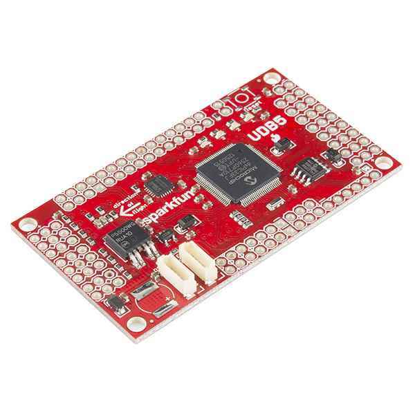
UDB5 available now from SparkFun

11703-01a.jpg

We're excited to have UDB boards once again available for purchase over at SparkFun! [UDB5 from SparkFun]

This latest revision of the UDB switches over to using the MPU6000 digital accelerometer+gyro chip, which has been performing even better than the very solid UDB4's analog sensors. It is otherwise a very similar board the UDB4.

Along with this new hardware release, we've also released MatrixPilot 4.0, which includes new hardware support for this board, and also for Nick Arsov's AUAV3 board.  MP4.0 also improves cross-tracking and navigation accuracy, among other goodies.

Thanks to all the developers for their work adding support for new hardware, refactoring the code, and constantly improving performance! 

Read more…

Hexacopter fixed and ready to go.

I recentaly fixed my hexacopter which had crashed 2 weeks earlier (Here) 

This is my best flight since i fixed it.

Changes I made:

1. Moved Apm 2.5 from the bottom to the middle to reduce compass interference.

2. decided not to update to 3.0.1 because I'm familiar with 2.9.1

2. moved telemetry to bottom.

3.moved reciever to top so wires could reach amp.

Thanks to all the people who helped and gave me tips to fix my hexacopter and make it better

Read more…

DroneCafe.com - Update #1

3689538129?profile=original

Welcome to DroneCafe.com a place to hang out and talk about any drone topics including military applications, civillian applications, drone news Politics, etc.  We've added a few new additions that include:

  • Drone Cafe Chat Room (IRC Based)
  • Drone Cafe Skype Chat Room
  • Weekly Polls to allow members to determine the direction/development of the website at all times
  • Forum set up to archive the chat room conversations daily so if anyone wants to go back and read a previous chat room conversation this will be possible :)
  • Sharing awesome DIYDrones.com Content in the forums and setting Diy Drones content into personal categories to allow Drone Cafe users to easily find Diy Drones links and content while their enjoying their time on Drone Cafe
  • No longer in beta testing mode.  Now we're currently fully up and operational
  • Vimeo Video Integration
  • Sign in using social media accounts (Twitter,Facebook,Gmail, Linkedin, etc (will be finished Wednesday 7/24/2013 before 5PM CST

The Cafe

3689538153?profile=original

Weekly Poll #1

3689538077?profile=original

Thanks for checking out DroneCafe.com and what it has to offer :)

Read more…

At the summer 2013 Colorado FPV meet in South Park, near Hartsel, Colorado, a group of us did a special project. We did a one-way, point-to-point FPV flight from the top of a hill next to our campsite to the far side of a reservoir 8.6 miles away, handing off control from the pilot at the launch site (myself) to a pilot at the landing site halfway through the flight. We accomplished this using the multimaster mode on the Rangelink UHF Long Range System, which allows two (or possibly more) radios to be bound to a single receiver.

Here is the video combining footage from the onboard HD camera (a Contour Roam2) and ground recordings from both sites, along with ground audio from both sites. We coordinated the flight via cell phone, and you can hear the running dialog in the background.

The plane used for the mission was my Crash Test Hobbies Deep Reaper XL flying wing, equipped with Rangelink 433 mhz control and a 1280 mhz video link. The OSD onboard is a Cyclops Breeze Pro. The power system is a 1250kv Turnigy SK3 motor, 10x6 prop, 80A Detrum ESC, and 2x 4000mah 4S Zippy lipos. It also has an FY-30A stabilizer.

3689538023?profile=originalWe launched from the top of a hill, with clear line of sight all the way to the eastern shore of Spinney Reservoir, where the destination team was located. Here is the view from the launch site.

3689537975?profile=original3689538050?profile=original

Here is an overview of the flight on Google Earth:

3689537898?profile=original

The mission was not without its challenges. We were originally planning to use a different plane, but it was crashed in a test flight which busted its motor. After several unsuccessful repair attempts, we decided to switch to my Deep Reaper at the last minute. Since the destination team was already in position, we had to talk them through the settings for their radio over the phone, made easier since the control radios were a Turnigy 9XR and an older Turnigy 9X, both running the ER9X firmware.

We had also originally planned to do a two-way flight, changing batteries at the lake and flying back to the launch site. Since the other team did not have fresh batteries for my plane, and because of the lack of a clear landmark for the return flight, we decided to only do it one way. It was also pretty windy, which made keeping the plane level and flying in the right direction challenging. Multiple ground stations equipped with high-gain antennas were set up at each site for redundancy.

In the future we would like to experiment with doing a three-plus radio handoff, depending on the capabilities of the Rangelink multimaster mode and how many radios it can synchronize. And while on this flight, both teams had line of sight to the plane the whole way (the team at the lake was actually able to control the plane even before launch), this would enable flights up and over a mountain, which would be impossible for a single pilot to accomplish without breaking line of sight and losing radio contact.

All in all it was a very fun experiment, and I am very happy it was successful.

Read more…
Moderator

10 x zoom video camera for UAV/UAS

3689537968?profile=original

More information: 10 x zoom video camera for UAV/UAS.


10 X Zoom Video Camera Main Features:

  • Light and small 10x optical zoom camera
  • Remote controlled zoom with auto focus. Remote controlled manual focus.
  • Power Supply 10V-15V Recommended 12V
  • Sony 700 line has excellent overall performance and picture quality
  • Weight:118g
  • Size:38*40*65mm

3689537874?profile=original

3689537942?profile=original

Perfect for installation with BL gimbal in multicopter or larger fixed wing UAVs.

Read more…
100KM

Aerial mapping stitch by MS ICE

3689537758?profile=original

Recently Lianpin Koh suggest to me to try out the Microsoft ICE. It is an advanced panoramic image stitcher. The best part : It's a freeware.

Being just completed to map 20000 Ha of oil palm land for a local plantation, I have huge data set on hand to try out if it is suitable for general use. This is a pure images stitching program, so the end result is not geo reference.

The result is simply amazing. I just load all the images and wait for the program to finish the work. No editing or intervention what so ever. Depends on the number of images, my i5 8GB ram notebook take 15 to 20 minutes to finish a 350 images data set. I'm very impress with the stitching quality, the final image looks like it was taken by a single shot.

I do encounter some problem with area cover by thick tropical rain forest. MS ICE had difficulty to stitch those images and most of the time it just ignore it and leaving the area empty. I think this is a common problem for all UAV base photogrammetry program. 

The total area of this mission is about 250 Ha. The above image show smaller area because I have crop it. My Skywalker base UAV take about 30 minutes to cover the whole mission at 300 M altitude. The ground sampling distance is about 11 cm per pixel.

For those of you who just need an aerial photo of a big area, I think MC ICE can do a good job especially if the images contain many features. APM and Mission Planner is a real winning combination for aerial mapping. The system is robust and reliable. Give it a try, I'm sure you'll not disappointed.  

Read more…