All Posts (14049)

Sort by

Walkera FPV quad

3689518432?profile=originalWhile ordering parts for my V959 today, I perused the BG website a bit, and came across this little guy. I have been aware of it for awhile, but I decided to do a little more research, and am seriously considering buying one. It is the Walkera Ladybird V2 FPV quad. This thing is tiny, Its about 4 inches square, and a little over an inch tall, by my mental math (8.5cm square, 3cm tall). It has a built in FPV system operating at 5.8ghz, and THIS package comes with the DEVO4 controller with built-in video screen. The control board has built in 3 axis gyros, and 3 axis accelerometers. The whole thing ticks in around $200 US. I have been saving pennies for either building, or buying a pre-built quad to use for APV and FPV, but I may have to divert some cash the direction of this quad.

These little all-in-one packages are becoming more complex, and cheaper at the same time, which really amazes me. I have been looking at a couple of other quads with interesting bells and whistles, and thinking about how the technology could be applied to my personal interest, disaster relief, but I will go into that at a later time. 

Read more…
Developer

Providing the user / pilot a good feedback is very important.. Right now most autopilots just have 1-3 LEDs, but no interaction concept. We would like to collect some feedback on this topic. It takes less than 60 seconds to complete and will help us a lot: Link to survey

Based on this feedback and general UI concepts we're trying to come up with a consistent interaction concept using the different LEDs, switches and buzzers to make the operation of the PX4 hardware as user friendly and safe as possible.

Read more…
Moderator

Today Marco doing a great test with his Hexa and VRBrain  he used firmware Arducopter32 2.9.2b developed by official DIYDRONES Team and ported on VRBrain and supported by VRI Lab Team.

The Dev Team doing a great work :) The main advantages of VRBRain is that is 30x faster of standard APM 2.5. The main difference is processor: VR Brain use STM32F4 168 mhz  and integrated FPU . APM used a standard AVR 8 bit processor at 16 mhz.

On VRBrain the scheduled time task  is respected at 99% , we have 80 % of cpu time in idle  and 3/4 flash free for  future development of firmware and 1 year of test by our VRI flight team.

With this feature you have a great smoth flight and the attitude is processed at 500 hz  , sensor is update at 1 khz instead of 250 hz in APM 2.5. 

In this test the VRBrain is controlled directly by AndroPilot. The application is available on Google Play and supported by Android 4.x Pad and Smartphone.

The AndroPilot is connected to VRBrain by 3DR radio telemetry module directly connected to USB port of ASUS Pad.

In video is possible to see the guided mode and Follow me functionality available on AndroPilot application.

The AndroPilot use internal GPS Pad for position of Marco and send every some times and when Marco move the new point to drone that follow Marco during his travel in the field.

I think that this result is very impressive . The integration of different technology is developed very good , It's only an early stage prototype but the result is yet very good . 

The board use by Marco is VR Brain 4.0 with enclosure and 3DR Ublox GPS the quality of fix is very good. 

Thanks to Marco , Emile , Randy and the other guys of devteam for this great result. Thanks to Kevin for his great CGS Android Application Andropilot.


For more info of VRBRAIN : 

http://www.virtualrobotix.com/page/vr-brain-v4-0


Original blog post:http://www.virtualrobotix.com/profiles/blogs/arducopter-vr-brain-first-test-with-andropilot-in-guided-and-foll

Best

Regards

Roberto Navoni


Read more…
3D Robotics

3689518382?profile=original

From Mashable:

Last year, as part of Congress' mandate to prepare the American airspace for the age of the unmanned aerial vehicle -– or drone -– the Federal Aviation Administration (FAA) was ordered to designate six locations as test sites for this up-and-coming technology. These sites will be used to make sure drones are safe to be integrated into the airspace to share it with regular manned airplanes. Privacy advocates, for their part, have proposed that this is the perfect opportunity to test the drone's exceptional surveillance powers -– on fake, dummy cities specifically built for this purpose.

"You know those creepy images of the Nevada nuclear test site, with the fake houses and fake people? Think like that, but for testing drone surveillance," said Dave Maass, an Electronic Frontier Foundation (EFF) spokesperson, in an email to Mashable.

Both the Center for Democracy and Technology (PDF), another digital rights advocacy group, and the EFF included this original idea in proposals sent to the FAA yesterday. For Jennifer Lynch, the EFF staff attorney who wrote the group's proposal (PDF), "the goal of the test sites is to test the capabilities of drones and to plan for their integration in the national airspace," she toldMashable in a phone interview. "And as part of that we should have a rigorous testing program related to privacy and surveillance, so we need to see what drones are capable of doing."

To test the technology, the groups have called for what the CDT called a "mock testing environment" — basically fake houses and businesses. The idea is to then have drones fly over them and see how much data they can collect. If the military does the same thing to test weapons or missiles, why not do it for drones as well?

Read more…

2014 UAV Challenge Outback Rules Released

3.jpg

The rules and dates of the 2014 UAV Outback Challenge have been released - http://www.uavoutbackchallenge.com.au/index.cfm?contentID=49

The aim of this challenge is to design/build/operate a UAV beyond line-of-sight to search and 2.5km area for a missing hiker and drop a bottle of water to them within a 60 minute time limit.

The is a AU$50,000 prize for the winner, which is yet to be claimed.

Last year's first-place holder CanberraUAV used a APM2 based Mugin UAV and successfully found the missing hiker. Unfortunately, the bottle drop mechanism malfunctioned before they were over the hiker.

This competition attracts entrants (both amateur and university based) from across the world and it would be awesome to see more representation from the DIYDrones community.

(FYI - I am part of the CanberraUAV team, so I'm happy to provide further advice about the challenge)

Read more…


3689518099?profile=original

Tecscorp ­™ launch today its gyro stabilized gimbal Cyclop­™, with roll axis compatible with APM and for trex 600 heli, It is manufactured on carbon fiber and null vibration technology in its 3 axis. More info http://tecscorp.co/cyclop-gimball.html

Weight: 1.1 Kg with servos and physical connections.

Roll axis: +/- 40°

Till yaw Axis: 360 °

Gear reduction: ROLL 1;1 / TILL y YAW 4;1

Dimensions fo camera plate - 127 mm width

Inside Height: 148 mm

http://tecscorp.co/cyclop-gimball.html

Read more…
Admin


3689518139?profile=original


By MARTHA RADDATZ

At a remote-controlled model airplane field in Sarasota, Fla., Justin Woody was struggling to operate a mini-copter.

It was not a toy but an unmanned air vehicle, a drone, and Woody was getting hands-on training on how to fly a variety of them at a three-day session offered by the new Unmanned Vehicles University.

Woody is one of the current crop of students at Unmanned Vehicles University, the only institution in the United States to offer post-graduate engineering degrees, both masters and doctorate, in unmanned aerial vehicle systems. The program, which is the first of its kind, is the brain-child of retired U.S. Air Force colonel and F-4 pilot Jerry LeMieux.

http://abcnews.go.com/US/drone-school-teaches-students-fly-build-unmanned-vehicles/story?id=18923888#.UXdrg7WLDIw

Read more…

Free DroneMapper 2D Ground Control Point (GCP) Tool

GCPtoolDM.JPG?width=650We have released a test / alpha version of the 2D GCP generation tool for Windows. You may experience a bug or two but overall it should be functional. Let us know if you have problems working with the 2D GCP utility or have additional feature requests. 

Essentially, you want to create a list of images that the GCP appear in and load them into the tool. The images must be geo-tagged. Once, you've loaded all the images you can navigate between the imagery to add the 2D GCP locations. The GCPs appear in a small text box on the lower left side. When you've completed all the GCP you can save this list as the 2D GCP text file. The 2D GCP file is one half of the required GCP data needed for our processing chain.

Download Link

Let us know if you have any questions. 

Instructions for use:

ZOOM IN - Control Up Arrow or Mouse Scroll Wheel
ZOOM OUT - Control Down Arrow or Mouse Scroll Wheel
ADD GCP - Hold Shift Key and Click GCP Target
PAN - Right Click on Mouse and Drag (or use scroll bars)
NEXT IMAGE - Next Button
PREV IMAGE - Previous Button
SAVE 2D GCP - Save GCP Button or File -> Save
CLEAR 2D GCP - Clear GCP Button or File -> New

We will add additional features and fixes as needed. Best regards,
JP

Read more…

Hydrogen Fuel Cell UAV

A hydrogen fuel cell is a device that converts hydrogen gas & air into electricity and water. Although these devices are much lower power density than batteries, they can pump out that power for many hours, depending on the amount of fuel you are storing.

At Loughborough University UK, we are working on a fuel cell and LiPo hybrid, to give you the oompf for take off (and go-arounds!) and the long endurance for cruise and loiter.
The base aircraft is the Skywalker X8, modified to carry considerably more weight than it is designed for (currently 4.5kg all up, and pushing towards 6kg with more testing).
This video briefly explains the platform setup, shows a video using ArduPilot's autonomous take-off, and concludes with a short 4.5kg flight.
In the coming weeks look forward to videos of the payload approaching 6kg, and the fuel cell being connected properly and providing some of the power!

Read more…
3D Robotics

3689518128?profile=originalGood piece from Harvard Business Review. Excerpts:

Mass-market drones clearly hold potential for what Paul Nunes and I call "big bang disruption." This is a kind of innovation that, thanks to fast-evolving technology, arrives in the marketplace simultaneously better, cheaper, and more capable of improving than the existing alternatives.

....

As George Mason University's Jerry Brito pointed out in a thoughtful essay last month, "Small drones are made from many of the same components as smartphones, and the economies of scale of that industry have driven the cost of gyroscopes, accelerometers, GPS chips, and CPUs to the ground. As a result," Brito writes, "the widespread use of drones in commerce is imminent — unless politicians overreact to the bad press."

That last phrase, of course, is a big "unless." The FAA's impending deadline has created panic among state and local governments, who are falling over each other to legislate who gets to use drones and for what purposes before the FAA rules are issued. According to the American Civil Liberties Union, thirty states have already passed or are considering restrictions on drones, if not outright bans.

Local authorities are getting in on the pre-regulation act as well. Recently, the town of Rancho Mirage, CA joined Charlottesville, VA, St. Bonifaciuis, MN, and Seattle, WA in considering or adopting local rules restricting or prohibiting drones in their respective communities. In Alameda County, near where I live, a public hearing on a plan by the sheriff to deploy drones for law enforcement quickly turned ugly. "We oppose the use of public resources to buy machines to surveil its citizens," one resident was quoted as saying. Another rejected just the potential use of drones by the police as "an assault on my community."

It's not surprising that potential private and law enforcement use of drones invokes intense emotional responses, including fears of an expanded police state with an "eye in the sky" and the further erosion of personal privacy. The Rancho Mirage ordinance, for example, had its origins when a private citizen saw a model drone flying over his backyard. He asked the operators to relocate their activities, and they did. But he wrote to his mayor the next day anyway.

The visceral objection we're seeing to drones is a great example of the "creepy response" I wrote about in a previous post. Novel uses of information technology often trigger deeply negative emotions, particularly among Americans. The truth is that we usually adjust to the new technology by coming to recognize that its benefits outweigh the costs. In the interim, however, the temptation to regulate it out of existence is hard to resist.

And of course, the use of the term "drone" doesn't help. Drones, like many of the most valuable innovations of the past century, began life as military technology, and have notably been used for targeted killings as part of the so-called "war on terror." Hobbyists have made a serious tactical error in adopting the same term for unmanned aircraft that, at least so far, have no weapons attached to them.

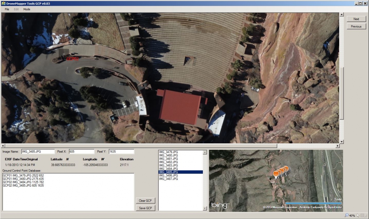
As understandable as the psychological response may be, however, there is a serious problem with the rush to regulate. Overreacting to fears of the unknown could prove disastrous to the development of technology with tremendous potential to benefit society. Drones could make safer and cheaper a number of essential activities that today require human pilots, and also make other activities possible that are today simply unfeasible. These include emergency transportation of supplies to remote areas, agricultural monitoring and maintenance, aerial photography and mapping, protection of wildlife from poachers, pipeline inspection — perhaps even local delivery.

As with any emerging, potentially revolutionary new technology, it is impossible to anticipate all the uses to which unmanned aircraft might be put once they reach mass markets. And therefore, it is hard to know whether existing laws are adequate to limit or ban the potentially destructive uses. Indeed, many of the local authorities considering drone legislation believe the FAA's current restrictions give them a rare opportunity to regulate before a dangerous new technology gets a chance to become mainstream. "We certainly want to get ahead of that curve before there are some abuses of that information," one Virginia legislator said.

As drones continue to become better, cheaper, and more useful, the legal debate is sure to heat up. But until and unless we get more evidence of what "abuses" will actually appear, drafting appropriate laws will be impossible. The mishmash of laws, restrictions, and bans add up to a response that is inefficient, imprecise, bound to cause collateral damage — and certainly not worthy of a drone.

Read more…

The future of GPS

Hopefully we have dodged the bullet and this post can be marked up as "paranoia"

Potential threat of GPS disablement!   I know this has been an ongoing issue for a while. A company called LightSquared has been trying to build a cellular network that interferes with GPS.  You don't hear much in the news about it these days, but it seems that maybe the threat has not completely gone away yet.

Although LightSquared was denied the frequencies after building out much of a network and had to file for bankruptcy, they are still petitioning the government to try to get a deal that would allow them to use some of the frequency's that are a little further from the GPS frequency. And apparently some venture capitalists seem the think that somehow the network could be resurrected and salvaged.  Still there is a strong resistance from the Airforce, Trimble, and others, but I am worried that the power of big money could prevent this threat to the GPS system from going away.

Does anybody have an updated status on this issue?

When I hear about problems with GPS inaccuracies and runaways, I wonder if testing of the lightsquared network might be going on, or similar cellular interference could be a factor.

Interference on GPS and other links we use in out UAV's bring to mind the concern as it already applies with existing RF sources in our environment.   There is a spot I would love to do a fly around getting some nice video, but a cell tower and some other towers sits on the top of the hill that I want to video, along with various other frequencies such as 2 meter, 70cm, GPRS an cellular services from Sprint, AT&T and maybe others.  Probably not a good place to fly!

Anyway, the LightSquared technology is referred to in some articles as LTE, I know that LTE is been deployed around the country, so it doesn't seem to be the same LTE that light squared plans to deploy is it?  as far as I can tell, so far they have been blocked from deploying the GPS blocking technology and lets hope they continue to be blocked!


Here is the latest thing I can find on it right now on the position of the FCC:    

http://www.gps.gov/spectrum/lightsquared/

Anyway, hopefully, like I said: we have dodged the bullet..

Read more…

Eric_Schmidt_at_the_37th_G8_Summit_in_Deauville_037.jpg?width=400

As fellow believers in the transformational power of technology, we at the DC Area Drone User Group were surprised and saddened to read of your recent comments in multiple fora urging increased restriction on the use of small drones. These positions are particularly surprising coming from the Chairman of Google in light of your organization’s admirable support of the World Wildlife Fund’s efforts to combat poaching using drones and Matternet’s research into developing drones to deliver medicine in Africa.Ironically, right now due to FAA restrictions it is personally owned drones that are better positioned than government or corporate owned ones to be used for social good in the U.S. The DC Area Drone User Group is currently conducting a community service project with a park in our local area creating aerial trail videos and overhead maps to help the park manager track changes over time in plant and animal species inhabiting the area. It is illegal for the park to operate a drone themselves without going through a process with the FAA that is in practice too complicated and expensive for a small, local government entity to manage. It is also illegal for them to hire someone to operate a drone on their behalf since current regulations prohibit the commercial use of unmanned aerial systems. However, it is entirely legal for us to use our drones on a volunteer basis to help them better understand their own resources, an activity we are happy to help them with in an era where our public institutions are being asked to do more with less.You suggest that terrorists might use drones for nefarious purposes. However, similar technologies have already been available for years. RC aircraft, ground vehicles and watercraft have been around for decades with people mounting cameras and other payloads on them. And just because terrorists have used Gmail to communicate in the current era, in much the same way they used telephones in the past, does not mean that the world would be better off if we had restricted use of email and telecommunication technologies to government and big business. Are you suggesting that any new technology should be suppressed because it might be used for anti-social purposes? The answer to these challenges is to ban terrorism, murder, theft, and invasion of privacy, as we have already done. Restricting access to specific technologies is always a losing game as bad actors will simply find new tools to cause harm to our society.What your comments exemplify is a trend, unfortunately common in our society, where some people are afraid to see individuals gain access to tools that in the past have been the exclusive domain of governments and big corporations. As drone technology has become cheaper, smaller, and easier to use, we are seeing ordinary citizens and community groups become self-sufficient in areas where they previously had to rely on others. Farmers can check on the health of their own crops from the sky without having to pay for expensive manned aviation. Communities can map their own natural resources without having to buy costly satellite imagery.Personally owned flying robots today have the power to change the balance of power between individuals and large bureaucracies in much the same way the Internet did in the past. And just as the military researchers who developed GPS for guiding munitions could never have imagined their technology would be used in the future to help people conduct health surveys in the world’s poorest countries or help people find dates in the world’s richest, there is a whole world of socially positive and banal applications for drones that are yet to be discovered. We should embrace this chance that technology provides instead of strangling these opportunities in their infancy. Our hope is that you and the rest of Google’s leadership will embrace this pro-technology agenda in the future rather than seeking to stifle it. We would welcome the opportunity to speak further with you about this topic.Timothy ReuterPresident and FounderDC Area Drone User Grouphttp://www.dcdrone.orgThe DC Area Drone User Group is a community organization that seeks to promote the use of flying robots for community service, artistic, entrepreneurial, and recreational purposes.
Read more…

Results of two years of work.

This is the result of two years of intense work with major support from Diydrones without this project would have been impossible.
The results are a UAV to perform accurate flight plans in order to photograph large areas with the overlap needed for later processing by a powerful photographs photogrammetry program.
The project has been presented at the Polytechnic University of Cartagena UPCT with great acceptance.

Read more…

A new wing design

I've been working on a new wing. The price of tooling is a killer!3689517938?profile=original

It's tested and I'm very happy with the results, just think about what might be the most effective version and what to put our efforts into if at all. All designed in Rhino CAD and Solid Works so mods are no problem.

We have two build options a carbon fiber/glass version and foam version. 2 Factories have expressed interest.

Propulsion Electric , 2 control surfaces
MTOW TBA
Empty weight TBA
Wing span 3.1 m
Length 1.94 m
Wing area 2.1 m2
Motor power Brushless electric 2000 watts (~2.6hp)
Max payload inc. energy TBA
Payload area Total 10 l 
Cruise speed TBA kph
Stall speed 21 kph
Max speed TBA kph
Airfoil type Aeronautical Advanced C

or 

Propulsion Electric / Petrol, 6 control surfaces
MTOW 17 kg
Empty weight 7 kg
Wing span 3.1 m
Length 1.94 m
Wing area 2.1 m2
Motor power Brushless electric 2000 watts (2.6hp)
Max payload inc. energy 10kg
Payload area Total 16 l 
Cruise speed 108 kph
Stall speed 21 kph
Max speed 140 kph
Airfoil type Aeronautical Advanced C
Build material Carbon fiber / CF

3689518023?profile=original

3689517897?profile=original

3689518047?profile=original

Any comments are welcome.

Read more…
Developer

[Update] DroidPlanner v0.7.5

I added some neat features on DroidPlanner, so I'm posting an update. The new app (v0.7.5) is on Google Play.

3689517985?profile=original

The new version has the following updates ( v0.7.5 over v0.7.0):

  • Notifications using Text To speech, which are very helpful since you don't have to look at the screen. There are notifications for things like: Battery discharge, flight modes changes, GPS lock, waypoints...
  • Logging files are now compatible with Mission Planner, which means you have all the information from the telemetry for a post-flight analysis.
  • Improvements to the HUD layout, including new information like Battery capacity.

  • Fixed some bugs on the RC screen, and makes the virtual sticks work more similar to a real TX

Tablet Mount

As you may have noticed on the above picture I made a tablet mount on my TX. It was easy since I already had the tablet car/mount, so just a way to fix it to the radio was needed (done by an aluminum bar). A small modification to the TX was needed, but it was worth the effort. The 3DR telemetry dongle is held in the tablet using Velcro. Here is a picture from another angle.

3689517870?profile=original

This makes DroidPlanner a useful tool when flying with Ardupilot  especially with the voice notifications. On the top picture you can see a rotatory switch a had added to the radio for the Mode channel, it was a pain to keep track of what position mapped to which mode.

And as always if you want to help consider donating for the project by buying this app, joining the development team, or reporting a issue/bug/improvement on GitHub. For more information I suggest the DroidPlanner Wiki page. Or older posts on DiyDrones.

Read more…